 Earth Science Today
Russ Colson
Minnesota State
University Moorhead
Weather and Climate:
Topic 1: Weather, Winds, and Rain
In October of 1732, an eclipse of the Moon, which Benjamin Franklin had hoped
to observe from Philadelphia, was obscured by a storm. The storm was a
"Nor'Easter", a storm with strong winds from the Northeast.
Yet, further to the Northeast, the storm began much later and the eclipse was
visible. Benjamin Franklin writes "This puzzles me, because the
storm began with us so soon as to prevent any observation; and being a
northeast storm, I imagined it must have begun rather sooner in places farther
to the north-eastward than it did in Philadelphia."
But it didn't. The storm began first
downwind. Thus Benjamin Franklin documents one of the first clues to the
nature of storms and where they come from.
This story also illustrates that the real discoveries
in science are the things that are confusing, that don't fit our existing
mental model of nature. It is interesting that from the disappointment of
missing the eclipse was born a more fundamental discovery about weather.
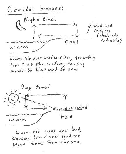
- Where does the wind come from?
All weather, including winds,
results from the attempt to balance out the uneven distribution of solar energy
on Earth. In general, for example, there is more energy at the equator
and less at the poles. Sometimes local heating imbalances arise due to
differences in how much sunlight is absorbed by the earth.
These heating imbalances result in differences in
pressure from one place to another on both global and local scales.
Differences in pressure result in winds, as the air attempts to move from areas
of high pressure to areas of low pressure (illustration
of how pressure differences and winds result from differential heating in
coastal areas).
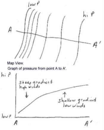
The key to what makes winds go is not simply
pressure, but pressure differences from one place to another. Pressure
differences are usually shown on a map with isobars, lines that pass through
points with equal pressure. Isobars allow us to quickly see where the
pressure at Earth's surface is high and low (exercise in
drawing isobars, est4a1.html). The difference in pressure can be
expressed as pressure gradient. Pressure gradient indicates how
steeply pressure changes from one location to another. It is analogous to
the steepness (gradient) of a ramp. Just like a ball rolls faster down a
steeper ramp, wind blows more strongly in a steeper pressure gradient. (illustration of pressure gradient).
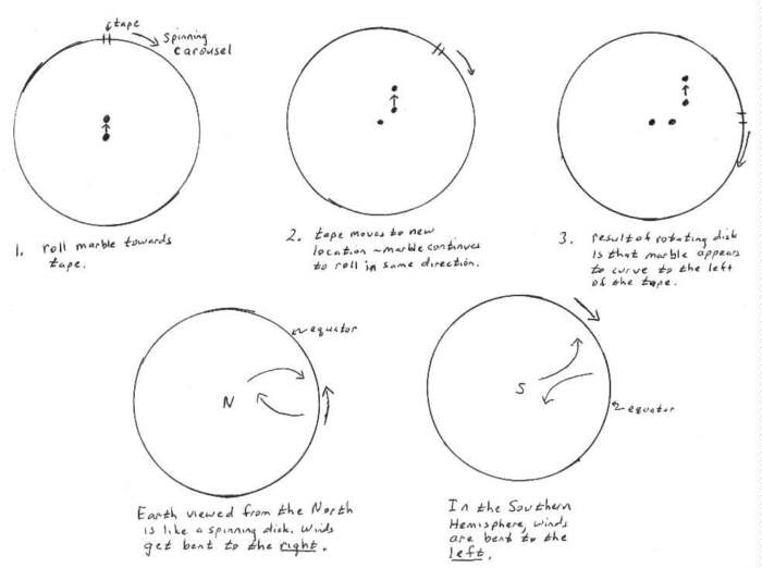
One might expect that wind will blow directly from
high pressure to low pressure areas, but, because the Earth is spinning, this
does not occur. The Earth's spin causes the wind to bend due to a Coriolis
Effect. You feel this effect on a spinning merry-go-round when you
try to move inwards or outwards on it. You feel a force pulling you to
one side. Winds on a spinning Earth also respond to this effect.
You can also illustrate this effect by rolling a marble on a spinning carousel
(such as might be used for cakes) (illustration).
The coriolis effect causes winds to be bent to the
right in Earth's northern hemisphere and bent to the left in the southern
hemisphere. If we ignore the effect of friction between the wind and
Earth's surface, the winds will be bent until the pressure force and the
coriolis "force" balance each other. This occurs when the winds
are parallel to the isobars (illustration).
The result of this effect is that winds circulate
counterclockwise around low-pressure centers in the northern hemisphere of
Earth (you can understand this by imagining the winds trying to blow toward the
low, but getting bent to the right, causing them to circulate
counterclockwise). Winds circulate clockwise around high pressure
centers. In the southern hemisphere the circulation is the opposite,
clockwise around lows and counterclockwise around highs. This circulation
means that given the wind direction you can estimate where a low pressure storm
is relative to your own location. Stand with your back to the wind,
stretch out your left hand sideways and it points approximately in the
direction the low is from you (You always wondered what those guys were doing
standing around with their arms out!). (wind
direction and velocity puzzle).
Because strong storms often move out of the
southwest, an easterly or southeasterly wind can presage a storm. Also,
the strongest part of a winter storm is usually in the northwest quadrant of
the low pressure center (go look at the isobar exercise above, and figure out
what direction the wind in Fargo-Moorhead was blowing from during the storm of
Nov 28, 2000, and what quadrant of the low we were in - answer).
So winter storms often occur when a low passes to our south.
The way that the wind changes direction as a storm
approaches reveals whether the low is passing north or south of us. A backing
wind is one in which the wind shifts in a counterclockwise direction (from
south to southeast to east to northeast). A veering wind is one in
which the wind shifts clockwise (from south to southwest to west to northwest).
You can figure out whether a backing or veering wind is a harbinger of a major
winter storm (backing and veering wind puzzle).
- Where does rain come from?
Why, from clouds, of course!
But where do the clouds come from? A friend told me of a teacher in Fargo
who asked his 8th grade class what clouds are made of. When they said
"water" he ran out of the classroom, got a big bucket full of water,
ran back in, and threw the whole bucket full of water up into the air.
When it came splashing down, he asked them with a tone of dismay "What
happened? "Where is my cloud?"!! (someday I'm going to
work up the courage to do that!)
Clouds are formed from water that was dissolved in
the air and condenses out in small droplets. We can watch water dissolve
into the air when we boil water. The water becomes part of the air.
When we set our cold Coke can out on a hot, muggy day, we can see the water
undissolve, it condenses back out of the air. From these two
observations, we can infer how the solubility of water in air (that is, how
much water dissolves in the air) depends on temperature, which is the key to
understanding how we get clouds (thought puzzle,
est4a5.html).
Dewpoint is the temperature at which water
will start to condense from air as it is cooled. Dewpoint is therefore a
measure of how much water is in the air.
Relative Humidity is the amount of water in
the air/amount of water the air can hold at that temperature x 100%.
Relative humidity is therefore a measure of how much water is in the air
compared to how much water the could possibly hold at that temperature.
Since cold air can hold less water than warm air, we can squeeze
water out of the air simply by changing the temperature of the air (to make
dew, or fog, or snow or clouds, ~ 3 minutes
to load at 14.4K baud)!
If we cool the air, it will hold less dissolved water, and some of that water
will condense out as liquid or solid water.
So how can we cool air?
One way is simply to radiate energy away from the
Earth at night (black body radiation). This cools the ground, which cools
the air next to the ground. Under these conditions we may get dew, or
frost, or fog as water condenses out of the air near the ground.
But the big way to cool air for making clouds and
rain is by adiabatic decompression (isn't that the coolest thing to
say?). When air is compressed, its temperature rises. When air is
decompressed, its temperature falls. You can observe this with a manual
tire pump. The pump gets hot as you compress the air into your
tire. Cans of compressed air can be purchased (for cleaning items you
don't want to get wet). The nozzle of these get very cold as the
compressed air decompresses on its way out. But maybe the easiest way to
observe this effect is with a balloon. Blow up a balloon, then hold it
against your cheek and let the air out quickly. You can feel the balloon
cool as the air in it decompresses.
Because pressure is lower higher up in the
atmosphere, rising air will decompress and cool adiabatically. Air may
rise because it is warm and buoyant (warm air is less dense and rises), or air
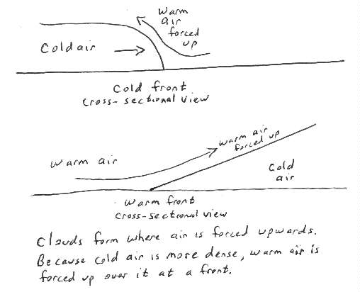
may be forced up over mountains by winds, or air may be forced up by a cold or
warm front (illustration). Regardless of how
the air is made to rise, the rising results in decompression and cooling.
The cooling can squeeze out the water dissolved in the air, and we get clouds
and precipitation.
The evaporation and condensation of water is
one of the main ways that Earth moves energy (remember that weather is the
effort to even-out Earth's energy distribution). To evaporate water, you
have to add energy to it (think about adding heat to boiling water, or how
water evaporating from your skin takes energy from you and makes you
cooler). That energy doesn't simply vanish from existence. When the
water is recondensed as rain or snow, we get that energy back. This is a
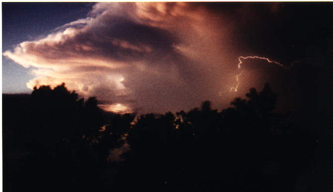
major source of energy driving storms such as hurricanes, thunderstorms, and
even winter storms. When water evaporates from the Gulf of Mexico,
travels on winds up to Fargo-Moorhead and falls as snow in a big winter storm,
the effect is to move a huge amount of heat from down closer to the equator to
up here closer to the north pole!
Illustrative activity: What are
condensation/humidity/dewpoint?.
Isobar and wind direction
activity-map reading (in MSword)
Home Page (est.htm) Previous Page (est.htm)