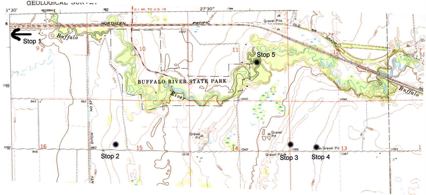
Topographic map showing field trip stop locations. You can also find topographic features we will be looking at, including wave-cut scarps, dune ridges, and former offshore bars.
Field Trip: Geological stories of regional climate
change. (2.5 hours)
Topographic map showing field trip stop locations. You can also
find topographic features we will be looking at, including wave-cut scarps,
dune ridges, and former offshore bars.
Stop 1: Sediment from the valley
The sediment in the valley is very fine grained (clay-sized). This
is consistent with its origin in a deep lake where surface waves did not
stir things up much. Fine-grained clay settled out in this lake.
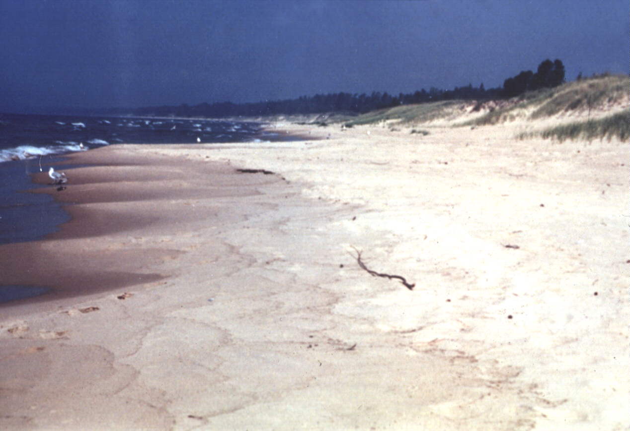
Stop 2: First beach scarp and sediment sample
The two clues to the nature of Lake Agassiz
are topography and sediment. We are at the top of a scarp believed
to be an erosional scarp at the edge of former Lake Agassiz. Similar
scarps are seen at the edges of modern lakes, like Lake Michigan shown
below.
Several of these beach scarps formed when
the lake was at different levels. This one is the lowest and most
recent one, called the Campbell strand line. Lake Agassiz is thought
to have been at this level from about 10800 years ago to about 9300 years
ago with a period in between where the lake drained. As we continue
up the road we will come to the Tintah strandline, the Norcross strandline,
and finally the Herman strandline. Each represents a level that the
lake stood at long enough to develop a scarp. The lake level fell
because the lake outlet (near Lake Traverse) eroded to progressively lower
levels.
The terrain here is underlain by sandy sediment.
Look for sandy soil and sediment dug up by gophers. The source of
the sand was the beach sand left by the retreating lake.
Stop 3: Top of Norcross scarp, with sand dunes
Image is looking up toward the scarp, just below the tree.
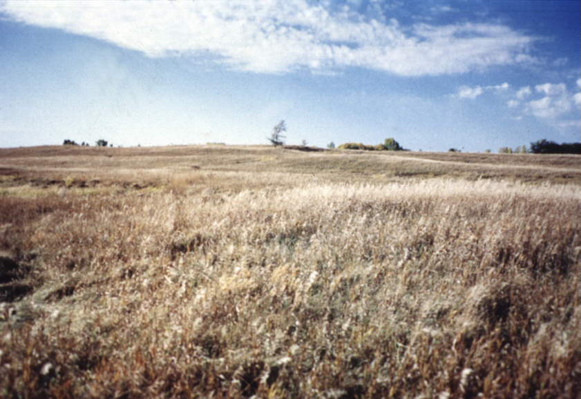
At this stop, we are at the top of another beach scarp, the Norcross.
The rolling terrain here again represents dunes, formed perhaps from sand
blown in from the former beach immediately below us. Sand dunes often
form on the scarp above beaches of modern lakes, such as the Great Lakes.
Imagine a time when the beach of Lake Agassiz was at the base of the scarp
below you and the cold, blue lake stretched over 50 miles to the West.
The rise to the East is part of a ridge that may represent an offshore
bar that formed at a time when the lake covered the area where you now
stand.
Below is a paleogeographic reconstruction of what this area may have
looked like when Lake Agassiz was at the Norcross level and the waves lapped
at the beach just below you.
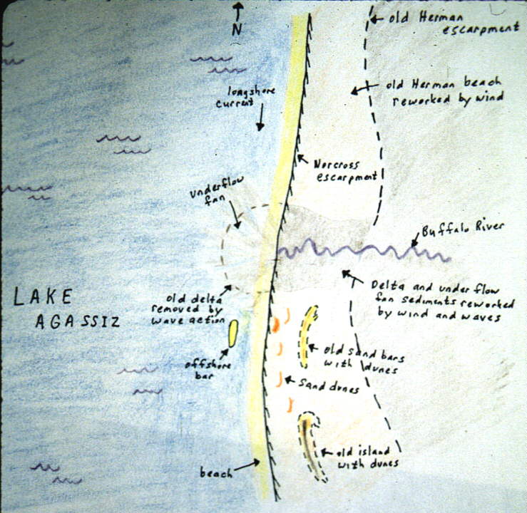
Below is a cross-sectional view showing the 4 major strandlines (Campbell,
Tintah, Norcross, and Herman), along with ridges formed by sand dunes and
ridges that may have been offshore bars during the time of Lake Agassiz.
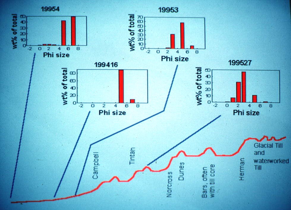
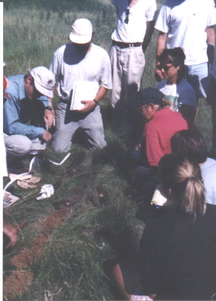
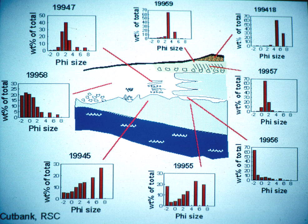
The image above also shows sediment-sizes in this area. These
data were collected by students in another class. Each graph shows
the distribution of different sizes of particles in the sediment, ranging
from fine grained mud on the right to coarse gravel on the left.
The sediment farther offshore is finer (more mud) but as you get closer
to the former beach the sediment gets coarser (sandier). The kind
of sediments in a particular location reveal the kind of environment that
used to be there. Beach sand is different from wind blown sand, or
river sand. Sediment in a lagoon is different from glacial till.
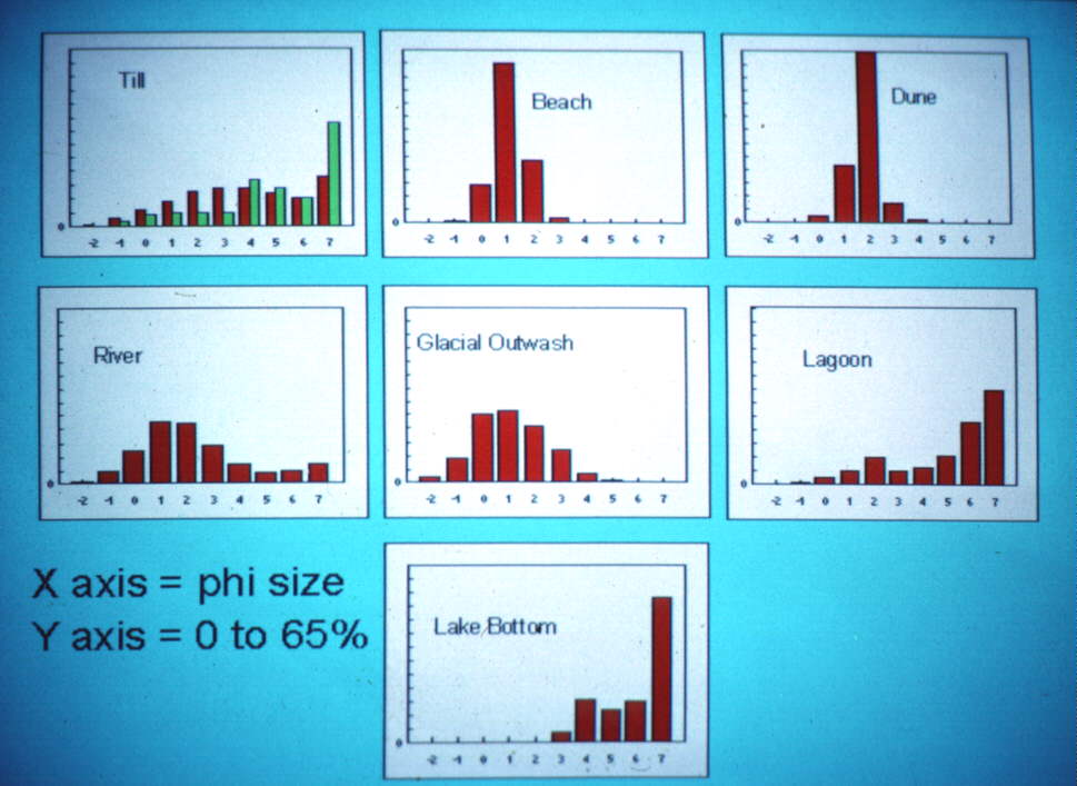
Here is a key to typical patterns of sediment from some different environments.
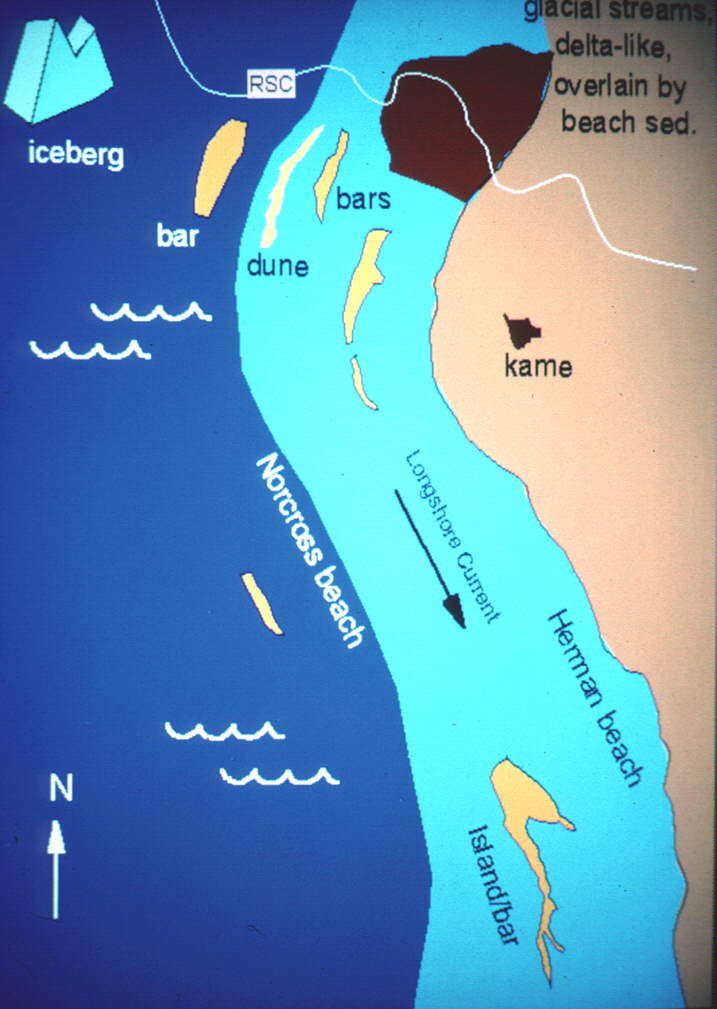
Stop 4: Herman offshore bar and lagoon
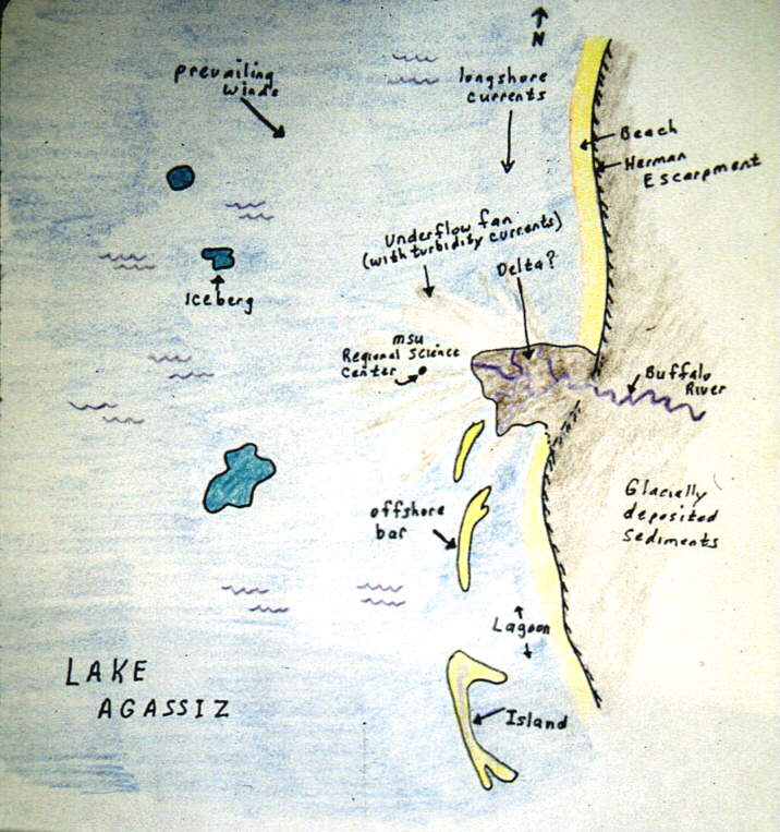
Below is a paleogeographic reconstruction of the
region at the time Lake Agassiz was at Herman level (about 11500 years
ago). Offshore bars existed and a delta or underflow fan probably
formed at the mouth of the Buffalo River. This delta has been mostly
obliterated by later wave action along the shore that occurred after sediment
volume from the river decreased (once the melting ice retreated to the
North and was no longer carried by the Buffalo River).
 (Alternate image of Herman times)
The ridgeline at this stop was an offshore bar at the time Lake Agassiz
was at Herman level. An offshore bar is a ridge of gravel and sand
offshore from the beach but where storm waves break and a beach-like environment
develops. The offshore bar shelters more landward water from the
strongest of the lake-waves, thereby creating a lagoon environment.
So the area to our east was likely a lagoon during Herman level times (about
11500 years ago).
This ridge probably represents a high area
in the glacially deposited sediments that predated Lake Agassiz.
As the lake fell, this ridge became first an offshore bar and later the
edge of the lake.
Stop 5 (with 1/2 mile hike): Cutbank at Regional
Science Center
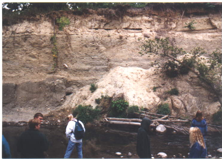
In the cutbank across the river, we see sediments
from past geological episodes in this region. Common sense suggests
that the sediments on the bottom must be the oldest and the ones on the
top the youngest, for how could the upper sediments have suspended themselves
in mid-air until the lower ones were deposited? Notice that the blue-gray
sediment at the bottom (to the left of the small landslide in the picture)
seems to be a mixture of stuff of all different sizes, big boulders mixed
in with the fine-grained mud that gives the layer its color. This
type of sediment is said to be poorly sorted. We dont find this
kind of sediment being deposited in modern rivers, or beaches, or deserts.
We do find it forming beneath glaciers. Thus, this sediment would
seem to have been deposited when this region was covered by glaciers.
It is called glacial till.
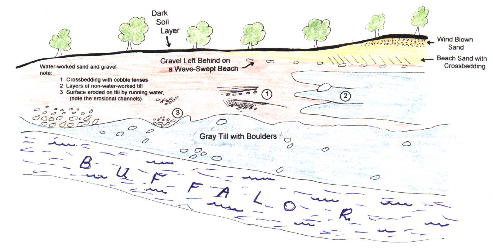
The boundary between this sediment and
the more yellowish sediment above it is very irregular and bumpy.
The bumpiness suggests that the surface between these two sediments represents
a period of erosion into the glacial till, with the irregular areas representing
channels cut into the till by running water. In addition, the sediment
above contains crossbedding and is sorted like river sediments, which are
not as poorly sorted as glacial till.
If the lighting is good, you may be
able to make out some faint fingers of blue-gray till within the yellowish
river-like sediments (just above and left of the small landslide in the
picture). This suggests that the rivers that eroded the glacial till
and deposited the river-like sediments may have existed within the glacier,
perhaps as it was melting away.
A few feet below the top of the cutbank,
on the right-hand side, you may be able to spot a roughly horizontal layer
of boulders (directly above the landslide in the picture). Above
this layer is a layer of crossbedded sand a couple of feet thick.
This sand contains almost no muddy sediment (unlike rivers or glacial till),
and thus is believed to have been deposited on a beach where constant washing
by waves washed away any muddy sediment. Thus, we conclude that this
sediment was deposited on a beach of Lake Agassiz, which formerly occupied
this region. The layer of boulders is called lag. It is the
stuff in the underlying sediment that was too large for the waves to wash
away.
Finally, above the crossbedded beach
sand is another layer of sand, seen only in a small area at the very top
of the hill. This is believed to be wind-blown sand deposited in
an arid period of time after the lake shore retreated away from this area.
Above all the sediments is a dark layer
of soil.
Sediment types tell us about past environments. The till layers are
muddy, but also have lots of sand and gravel (poorly sorted). The
sediment worked by rivers running within the ice has had much of the mud
washed away and so is better sorted, but has some mud still mixed in with
the sand and gravel. The beach sediments are very well sorted sand,
and the wind blown deposits are fine sand and silt, also well sorted.
The story of change is this: First came the glaciers, then the glaciers began to melt and rivers formed within the ice. After the ice was melted, a beach formed in this area. And finally, after the lake the beach formed on was gone, or had fallen to a lower level, wind blew sand into dunes and sandy flats. Later, once vegetation became established on the sand, soils developed such as the dark one we see today at the top of the cutbank.
Below is a diagram summarizing these interpretations.
Home Page (est.htm)
Previous Page (est4b.html)
image credits: Cutbank illustration by Mary and
Russ Colson and used for a hiking guide at the MSUM Regional Science Center.
Topo map from a 7.5 minute quadrangle map from the USGS.