Time and Change-Paleogeographic Mapping on North America
Earth Science Extras
by Russ Colson
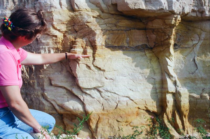
Beach and dune sand from the shore of the Cambrian Sauk Sea. Wisconsin Dells, WI.
Recap of Lecture
Extension of the lecture
A Look at the Ordovician
The Sauk see retreated during the Ordovician. Then, later in the Ordovician, another sea advanced across North America in like fashion to the Sauk Sea, again inundating much of the continent except for the transcontinental arch in the middle. This Ordovician epicontinental sea (a sea over continental crust, rather than oceanic crust) is called the Tippecanoe Sea. It was during the advance of this sea that many of the sedimentary rocks of southern Minnesota were deposited. For example, the sequence of St. Peter's Sandstone, overlain by Glenwood Shale, which is overlain by Platteville LImestone signal the arrival of the Tippecanoe sea in Rochester and St Paul Minnesota where these rocks are exposed. Younger alternating layers of shale and limestone seen in Mystery Cave in SE Minnesota might tell the story of alternating periods where the transcontinental arch was exposed (giving us shale when mud washesd into the nearby sea) and inundated (giving us limestone because there is no source of detrital, muddy sediments in southern Minnesota during that time.)
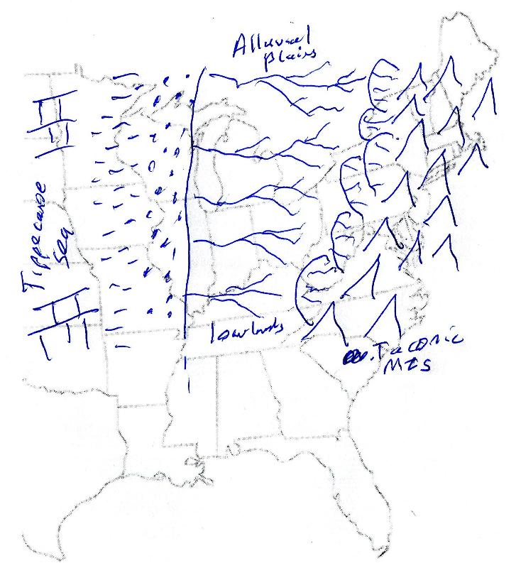
In Late Ordovician, a mountain-building event began on the east coast of North Amerca when a plate-tectonic convergence occurred there. This was the first of three big orogenies (mountain-building events) that happend on the east coast of North America during the Paleozoic. We are going to look closer at this event and think about how geologists reconstruct the paleogeography of these ancient events and landscapes. In looking at evidence for this orogeny, we're going to consider a depositional model a bit more complex than that used in the lecture. This also-simplified model is illustrated below.
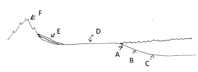
A, B, and C are the same as in the lecture: A is a wave-swept beach with sand, B is a quiet area offshore with muddy bottom, and C is limestone in a region with little supply of detrital sediment, often farther from shore. D represents alluvial (river) plains, a terrestrial depositional environment (as opposed to marine). Rocks formed in this environment might include alternating layers of shale and sandstone that formed as the river meandered through time. Often terrestrial sediments contain oxided iron, giving them reddish colors. These rocks won't always occur since rivers can sometimes erode sediment instead of deposit it, but we are using it in our depositional model for the problems below. E represents alluvial fans formed at the flanks of mountains where rivers that carry sediment eroded from the mountains slow down, depositing their sediment load. These sediments are often immature (angular grains, poorly-sorted mix of grain sizes, and minerals other than quartz, like feldspar and mica). They also often have a reddish color due to oxidized iron. The characteristic rock formed in this environment is arkose. F is an area of erosion, not deposition. This will be an area where sediments are not deposited and previous sediments might be eroded away. The geologic record of this event might be an unconformity in the rock.
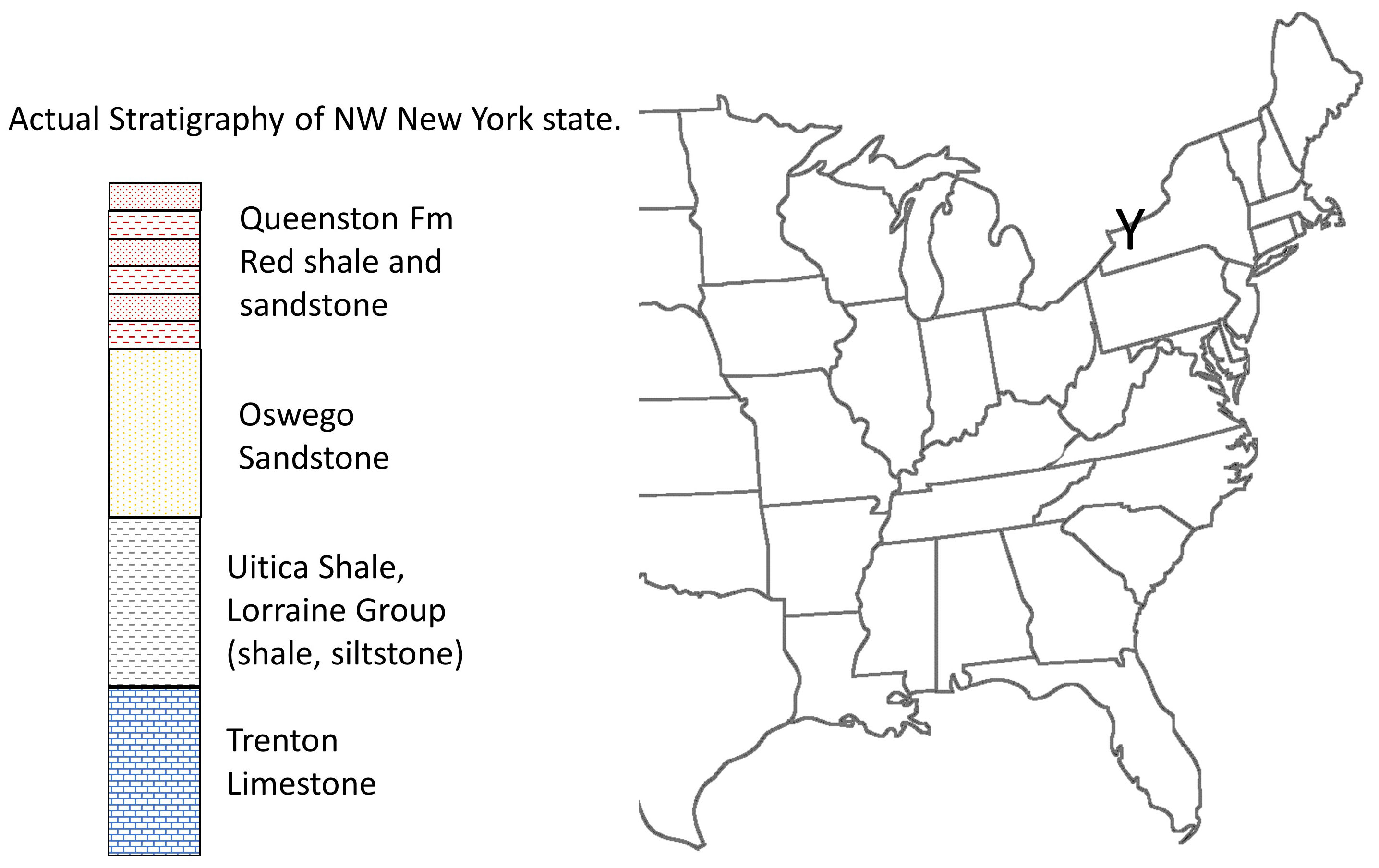
For the following question, consider both the depositional model described above and the Late Ordovician stratigraphy from northwest New York shown in the illustration below.
Below are hypothetical stratigraphic columns for several locatons on the east coast of North America during the late Ordovician. The columns are labeled as A, B, and C and correspond to rock at the points marked by A, B, and C on the map. The rock units are as described on the diagram, and we will assume the simplified depositional model above to be trrue for this scenario. Black lines connect different points of the stratigraphic columns that are the same age, labeled as T1 (for time 1), T2, T3, and T4.
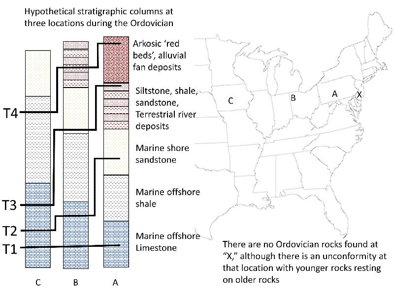
It can sometimes be hard to distinguish "evidence" from "conclusion" in historical science. The paleogeographic map above is a conclusion, that is, an interpretation of what we think the world was like in the past, not the evidence for it. The evidence is in the rocks themselves, which are shown symbolically in the stratigraphic columns above, although even those columns are a bit of an interpretation, since they are not actually the rocks themselves that we are seeing. Here is a philosphical question about evidence.
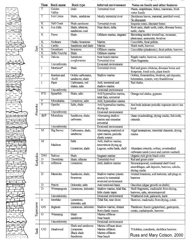
Study the stratigraphic column for western North Dakota below. On the left is a standard illustration of rock types. Next is a list of major depositional events in North America, the Sauk, the Tippecanoe, etc. These depositional events correspond to the major transgressions because deposition is more likely below sea level where standing water provides an environment conducive to deposition. Erosion is more likely above sea level where gravity and moving water conspire to destroy landscapes. Next over, the first column, is the time period abbreviation [although I made this chart before the Teriary (T) was changed to Paleogene (Pg) and Neogene (N)], The next column is the rock formation name (rock stratigraphic units), then the type of rock, then an interpretation of the environment the rock formed in, and finally a few observatons and features of the rock. There are more notes on the column at the end of this page.
As you study the cross section, think about the sequences of rocks and what they tell you. Look at the rock descriptions and think about depositional environments. Take note of how the rock types change at the beginning and at end of one of the marine transgression events. Pick a couple of time periods and do an internet search for paleogeographic maps of the time period (e.g. Paleogeographic map for North America during the Jurassic.) and compare the map with the rock evidence from North Dakota.
We've mentioned several alluvial (river) plains associated with mountain building-- the depositsof Queenston Formation as the Taconic Mountains were built in the Ordovician of the east coast, the deposits of Morrison Formation filling in the Sundance Sea as mountains built to the west, including the Nevadan range. Likewise, the Hell Creek Formation and Fort Union Group were deposited on alluvial plains as a range of mountains were built, again filling in a continental, epieric sea. Do some online research to learn about the time period of the late Cretaceous when this was happening (the Fort Union actually extends into the Paleogene, but with the environment of deposition much like the Hell Creek except there were no dinosaurs). What mountains were being built and where? What sea was disappearing as the sediment eroded from the mountains and filled in the sea? What did the paleogeography of this late Cretaceous time look like? Be sure that you find a couple of paleogeographic maps of the North America during the late Cretaceous. The questions below will test how well you did this miini-research project.
Reconstructing paleogeography requires that we think in both space and time as we consider the layers of rock and how they were deposited. Below are a couple of science reasoning challenges that test your understanding of the model that we have built-up as we went throught the questions above (the model is of a Cretaceous Western Interior Seaway that gets filled in by sediment eroded from mountains to the west and deposited in allluvial plains as rivers carry that sediment toward the sea).
More Notes for the Chart on the Stratigraphy of Western North Dakota.
Individual letters designate geologic periods of time: C (Cambrian), O (Ordovician), S (Silurian), D (Devonian), M (Mississippian), P in circle (Pennsylvanian), P (Permian), Tr (Triassic), J (Jurassic), K (Cretaceous), T (tertiary), and Q (Quaternary). (Note: Tertiary is an old term for what is now called the Paleogene and Neogene).
The names Sauk, Tippecanoe, Kaskaskia, Absaroka, and Zuni, refer to major depositional events in North America.
Relative thickness of rock units shown on this diagram is arbitrary and does not represent actual rock thicknesses.
An unconformity is a buried surface between two bodies of rock representing a break or hiatus in the record of geological events. It is often marked by erosional topographic features (buried hills and valleys), weathered rock, ancient soils (paleosols), or karst (caves weathered in exposed limestone).
"Salts" refer to a variety of evaporite deposits, including anhydrite, gypsum, and halite (table salt).
"Carbonates" refer to a variety of carbonate rocks, such as limestone and dolostone.
"Clastics" refer to particles like sand or mud that have usually been transported to a region of deposition, such as by wind or rivers.
References include publications dealing with specific rock units as well as the following: L. C. Gerhard, S. B. Anderson, J. A. LaFever, and C. G. Carlson (1982) Geological development, origin, and energy mineral resources of the Williston Basin, North Dakota, AAPG Bulletin No 8, V 66, p 989-1020; L. C. Gerhard and S. B. Anderson (1981) Oil exploration and development in the North Dakota Williston Basin: 1980 update ND Geol. Survey, Misc Series No 59, 19p.; J. P. Bluemle, S. B. Anderson, C. G. Carlson (1981) Williston Basin Stratigraphic nomenclature chart ND Geol. Survey Misc. Series No 61.; J. P. Bluemle (1991) The face of North Dakota, Revised Edition, ND Geol. Survey Educational Series, No 21, 177p.
* Although the Morrison is illustrated in Gerhard et al. (1982) as being present in the subsurface of North Dakota, Bluemle (1991) indicates that it has not been shown to be present there. We list it here because it is shown in several of the cited references and because it has been clearly identified across the border in Montana and South Dakota and represents an important stage of the regional geological history.
last updated 3/28/2020. Text and pictures are the property of Russ Colson.
