Structural Geology-Plate Tectonics
Earth Science Extras
by Russ Colson
Recap of Lecture--Faults and Folds
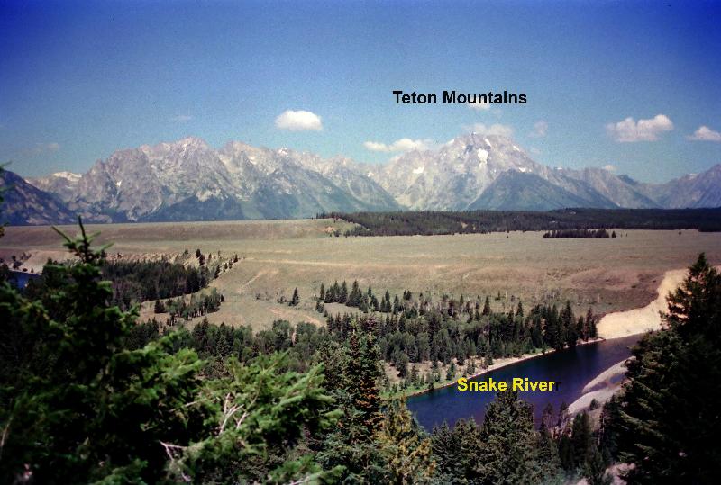
The San Andreas fault zone cuts across the southern California, running north and soutn. Using Google Earth, Google Maps, or another tool that portrays detailed landscapes as seen from space, check out features along this fault to see if you can figure out what kind of fault that it is. (I simply seached on San Andreas Fault to locate the fault and started trying to identify features.) Once you've done this, try to answer the question below.
The Enriquillo-Plantain Garden fault zone cuts across the southern sides of Hispaniola and Jamaica. Using Google Earth or another tool that portrays detailed landscapes as seen from space, check out features along this fault to see if you can figure out what kind of fault that it is (for example, look at the area just south of Port Au Prince Bay near Carrefour, Hispaniola. After doing this, try to answer the question below.
Plate Tectonics
People have known for a long time that the outlines of the continents can be roughly fit together like a jig-saw puzzle. They have known that earthquakes and volcanoes do not occur randomly just anywhere, nor do they occur in circular clusters, rather, they occur in linear or curved arrays. Mountain ranges are also linear or curved, not circular clusters. As we have learned more about the ocean, we have found deep ocean trenches paralleling volcanic and mountain chains, and long underwater mountain ranges paralleling the jig-saw outline of opposing coastlines of continents. Until the 1900's there was no theory that could unify all these observations under the umbrella of a single concept. Plate tectonics, accepted by most scientists in the late 1960's, provided that unifying theory. Plate tectonics has provided the theoretical underpinnings for our understanding not only of the modern geography of volcanoes, mountains, earthquakes, and ocean trenches, but it provides an explanation for why the geological past is so filled with change. It explains how Antarctica could have once been tropical and the Sahara once covered by glaciers. It explains how North Dakota was once home to coral and crinoid reefs. It explains how and why mountains formed where they did in the past, sometimes with repeated episodes of mountain formation over long periods of time. It explains many formerly inexplicable distribution of ancient creatures (such as how land creatures had distributional ranges that overlap what are now separate continents).
Plate tectonics is only one type of tectonics, a dominant type of tectonics on planet Earth. Plate tectonics is the major cause of tectonic processes on Earth, but is not obviously dominant on any other planet that we know of.
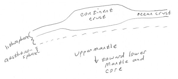
A lithospheric plate is the rigid part of the Earth's upper mantle plus the crust. It 'floats' on a more easily-deformed plastic (silly-putty-like) layer called the asthenosphere. These plates vary from about 70 km thick (under oceans) to 100-150 km thick (under continents) and are a few hundred to a few thousand kilometers wide. There are about 14 major lithospheric plates on Earth today. The plates have changed size, geometry, and orientation through geological time.
On Earth, these plates move relative to each other, correlated to convection of soft, plastic material in the Earth's mantle. Plates can move away from each other (divergent boundaries), toward each other (convergent boundaries), or past each other (transform boundaries). Convergent boundaries will be dominated by compressional deformation and divergent boundaries by extensional deformation.
Movement of plates puts enormous stresses on the Earth's crust, both compressional stresses (pushing together) and extensional stresses (pulling apart). If you imagine pushing a layer of silly putty together, it will thicken. If you pull it apart it will thin. When it is hot and under high pressure (such as in the roots of mountain ranges) the Earth's crust behaves a lot like silly putty. The thickening of the silly putty is analogous to mountain building. Mountain building is the result of Earth's crust thickening under compressional forces. Where the Earth's crust is colder, it breaks instead of flowing like silly putty. The breaks, with movement along them, are called faults. The faults have the same effect of either causing the crust to thicken (if compressed), or thin (if extended).
Plate tectonics accounts for many of Earth's major geographical features such as
Presence of deep ocean trenches
Mountain ranges
Volcanic belts
The high ridge running down the center of the Atlantic
Rift valleys
Ocean crust that is youngest at the central rift and gets older outwards in a symmetrical pattern
Convergent boundaries:
The picture below shows some of the key features of convergent boundaries where ocean crust is involved. Ocean crust is dense enough to be subducted, or pushed beneath other crust. This creates conditions for partial melting beneath the crust and the molten material rises to the surface to make volcanoes of andesitic composition. Other features of this type of boundary include compressive faults (reverse and thrust faults), mountain ranges, metamorphism and folding in the deep roots of the mountains, and deep ocean trenches where the ocean crust is subducted.

Modern examples of this type of boundary where ocean crust is subducted beneath ocean crust include Japan, the Philippines, and the Aleutian islands. Examples where ocean crust is subducted beneath thicker, less dense, continental crust include the Andes and Cascade Mountains.
Continental crust can also converge with continental crust. In this case, because continental crust is less dense than ocean crust, there is no subduction, little volcanism, and no deep ocean trench. The key features at these boundaries are mountains, folds and metamorphism, and compressive faults (reverse and thrust faults). Modern examples include: the Himalayas and the the Alps.
Divergent boundaries:

New crust is formed where ocean plates diverge, which, as time passes, creates a symmetrical pattern in which the age of rock increases outwards from an oceanic divergent boundary. The volcanism at divergent boundaries tends to be basaltic (less SiO2-rich and generally less explosive than the andesitic volcanism at convergent boundaries). Faulting is dominated by extentional faulting (normal faults) rather than compressional faulting. Often basaltic lave intrudes along the fractures formed by the normal faults, making basaltic dike swarms (dikes are intrusive igneous rock bodies that cut across layered rocks). Because the rock is hot at the center of the divergent boundary where underlying hot mantle material is rising, it is less dense that surrounding rock, and so rises higher, making a high ridge.
Modern examples: The mid-Atlantic ridge, the Red Sea and Gulf of Aden
It's also possible for continental plates to diverge. In this case, the lava is often more enriched in alkali elements like Na and K (called alkaline basalts). As continental crust diverges, long valleys are created where normal faults form of either side of the valley with the down-dropped side of each fault lying between the two upthrown sides. These valleys are called rift valleys.
Modern examples include the the East African Rift and The Rio Grande Rift.
Ancient Plate Tectonics
Lithospheric plates are consumed (subducted) at convergent boundaries in cases where ocean crust is involved (remember, continental crust does not get subducted), and new crust is created at divergent boundaries. Thus, there is great capacity for the character of the Earth's surface to change through time. Where convergence occurs, we can expect mountains. Where divergence occurs, we can expect the formation or widening of seas. Modern mountain ranges are in places where convergence is occuring presently (such as the Andes, the Cascades, the Himalayas, the Caucasus, the Alps, the island of Japan). Ancient convergence explains the presence of ancient mountain ranges. For example, just before the age of the dinosaurs, Africa converged with North America and made the Appalachian mountains in North America and the Atlas mountains of northwest Africa. The coliision between North America and Africa was part of the formation of the supercontinent Pangea.
The Atlantic Ocean wasn't there at the beginning of the age of dinosaurs when the great supercontinent Pangea began to break up. The Atlantic has formed in the place where North America and Africa spread apart.
The Urals are the result of the convergence of two ancient plates into one single plate (the Eurasian plate). An ancient ocean that once between those two plates closed as Europe and Asia grew closer together and collided, and, in fact, we can find pieces of ancient ocean crust caught up into the Ural mountains.
last updated 3/27/2020. Text and most pictures are the property of Russ Colson, with appreciation to NASA and Google Earth for images of Ganymede and Earth from space.
