
Soils in Stratigraphy and Construction Engineering
Earth Science Extras
by Russ Colson
Multiple buried soils at the Rustad Archaeological Site near Kindred North Dakota. Geographer Gary Running is pointing out the dark band of one of the buried A horizons in an alluvial fan deposit containing human artifacts from around 9000 years ago. More recent A and B horizons can be seen at the top of the image.
Soils can play a number of important roles in the interpretation of ancient rock and sediment deposits.
1) SInce soils form in place at the earth's surface, they can mark places in a stratigraphic sequence where humans might have occupied the landscape. This was the case at the Rustad Archaeological Site shown in the picture above.
2) Since a surface must be exposed for some significant period of time for a soil to develop, soils can be indicators of a period of non-deposition--a disconformity in the rock sequence--that might otherwise be hidden. Ancient tropical soil remnants are among the clues that the RedWall LImestone in the Grand Canyon was preceded and followed by periods of non-deposition and erosion.
3) Where repeated buried soils are present, they might indicate an environment of periodic deposition followed by long periods of exposure and soil formation. Such environments might include alluvial fans like that shown in the picture at the top of this lesson, or other alluvial deposits such as river flood plains where soil formation can be interrupted by periodic floods that cover the floodplain in a new layer of sediment. Many river deposits, such as the Morrison Formation famous for all the dinosaur bones found in it, are significanly affected by soil forming processes during the deposition of the sediments, giving us clues that the Morrison Formation was formed by periodic episodes of deposition of sediment broken by long periods of soil formation.
4) Soils can also be significant indicators of past climate. Understanding modern climate change, and the possible consequences of that climate change, depends to some signficant extent on understanding how climate has changed in Earth's past and what the consequences of those changes were. Ancient soils--paleosols--can give us clues about past world climates.
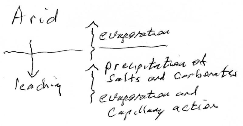
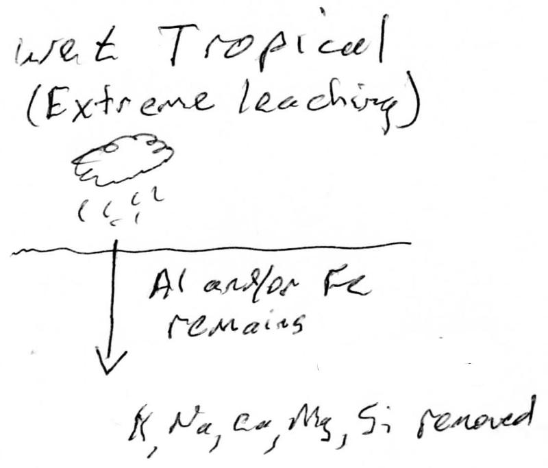
Soils, by their nature, form at the earth's surface and are therefore subject to erosion and less likely to be preserved than, for example, marine deposits. The examples of multiple buried soils given in the paragraphs above are all in aggrading (depositing) environments such as alluvial fans and river floodplains. However, there are some types of soil deposits that resist erosion (making them more likely to be preserved in the rock record) and prominent in their chemical and phyiscal character (making them more liekly to be recognized and correctly interpreted). These soils occur in particlarly severe environments such as wet, acidic tropical environments with extreme weathering and leaching that produces concentrations of Al and Fe oxides and hydroxides, or extremely arid climates with evaporative deposition of salts (e.g. halite, NaCl, and gypsum, CaSO4•H2O) and calcite, CaCO4.
In the case of arid climates, evaporation and capillary action draw soil moisture (containing dissolved salts and calcium carbonate) upward. As evaporative loss increases, the concentrations of the salts and calcium carbonate in the water increase to the point where they precipitate out as solids, forming deposits or layers in the soil, as illustrated below.
In the case of wet, tropical climates, the leaching can become extreme, particularly on a flat landscape (where water can penetrate deeply), and where there is acidic conditions and an abundance of organic chelating agents (which help otherwise insoluble materials like SiO2 to become mobile). Under these conditions, all primary parent materials are broken down by weathering, and nearly all chemical components are leached from the soil except for the most insoluble--often oxides and hydroxides of aluminum (Al) and ferric Iron (Fe3+). This process is illustrated below.
In some situations, the concentrated minerals can form a highly-durable layer that can be preserved over geological time. Examples of some durable layers include:
Calcrete: a layer of soil cemented with calcite deposited by evaporation or carbon dioxide loss, sometimes called caliche. These deposits are typically associated with aridisols.
Aluminocrete: a layer of soil indurated with aluminum oxides and hydroxides (when made mostly Al oxides and hydroxides it is called bauxite, an aluminum ore). These deposits are typically associated with oxisols
Ferricrete: The more iron-rich version of the aluminocrete (when made mostly iron and aluminum oxides and hydroxides it is sometimes called laterite). These deposits are typically associated with oxisols.
Silicrete: A layer of soil indurated by precipitation of quartz, sometimes associated with aluminocrete or ferricrete and indicative of Si mobility in the soil environment.
Kaolinite-rich soils can also often be preserved, formed in warm wet temperate or subtropical environments such as the southeast US with significant weathering and leaching, but less extreme than in the hot, wet, tropical environments. These deposits are typically associated with ultisols.
Consider the map below showing both modern soil orders around the world, plus approximate locations where various durable soils formed during the Eocene (between 34 and 55 million years ago) have been found. The modern soil map comes from (AO-UNESCO, Soil Map of the World, digitized by ESRI. Soil climate map, USDA-NRCS, Soil Science Division, World Soil Resources, Washington D.C. https://www.nrcs.usda.gov/wps/portal/nrcs/detail/soils/use/?cid=nrcs142p2_054013). The data on Miocene durable soil deposits is very roughly plotted based on data from the 2000 PaleoMAP project, http://www.scotese.com/climate.htm).
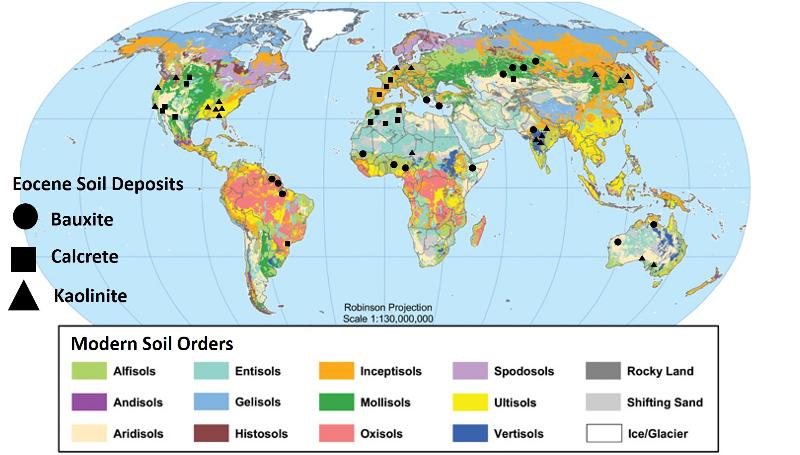
Note: The soil data is only a small part of the data we use to infer past climate differences. Including other data, we infer that the Eocene was perhaps 13°C (23°F) warmer than today, there were no permanent ice caps, and the concentrations of CO2 in the atmosphere were perhaps 3 times higher than today's values.
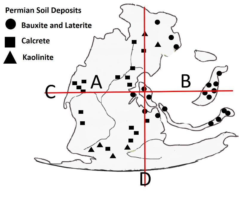
For our second paleosol puzzle, we are going back a bit farther in time to when the continents had a very different configuration before the breakup of Pangea. The continent outline for Pangea below is adapted from Tabor, N. J., C. A. Sidor, R. M. H. Smith, S. J. Nesbitt, and K. Angielczyk. 2018. Paleosols of the Permian-Triassic: proxies for rainfall, climate change, and major changes in terrestrial tetrapod diversity; pp. 240–253 in C. A. Sidor and S. J. Nesbitt (eds.), Vertebrate and Climatic Evolution in the Triassic Rift Basins of Tanzania and Zambia. Society of Vertebrate Paleontology Memoir 17. Journal of Vertebrate Paleontology 37(6, Supplement).
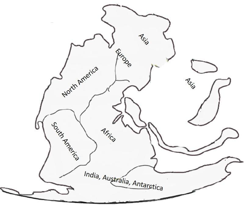
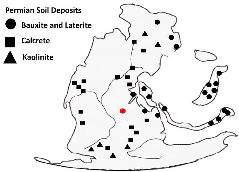
On this base map, I plot very roughly the locations of durable soil deposits of the mid- to late- Permian (The Permian lasted from 299 to 252 million years ago). (Locations of Permian durable soil data are approximated from the 2000 PaleoMAP project, http://www.scotese.com/climate.htm).
The study below comes from Tabor, N. J., C. A. Sidor, R. M. H. Smith, S. J. Nesbitt, and K. Angielczyk. 2018. Paleosols of the Permian-Triassic: proxies for rainfall, climate change, and major changes in terrestrial tetrapod diversity; pp. 240–253 in C. A. Sidor and S. J. Nesbitt (eds.), Vertebrate and Climatic Evolution in the Triassic Rift Basins of Tanzania and Zambia. Society of Vertebrate Paleontology Memoir 17. Journal of Vertebrate Paleontology 37(6, Supplement).
Isotopes of an element are atoms that have the same number of protons and therefore the same chemical properties, but have a different number of neutrons, which affects the mass of the atom and therefore affects how those isotopes partition among different mineral phases in an environment. Light isotopes, such as isotopes of carbon and oxygen, are often sensitive to variations in environmental conditions (such as temperature) and so provide insight into past climatic variations.
The graph below is based on measurements of carbon isotopes in modern environments. The value plotted on the y-axis is the difference in the delta carbon 13 value (a measure of the isotopes of carbon) between calcite and organic matter in soil environments. The x-axis plots mean annual precipitation in centimeters.
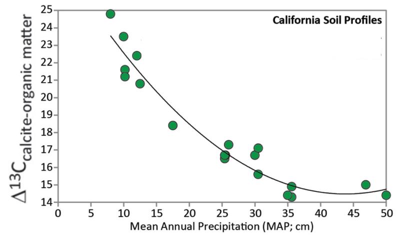
If we suppose that these modern measurements in California give us insight into how the C13 isotopes partitioned in the geological past, then we can apply the correlation shown in the graph above to the problem of inferring rainfall totals in the ancient past by measuring the C13 amounts in calcite and organic matter from paleosols.
The measured Delta C13 (calcite-organic matter) for a late Permian paleosol from Maradi, Niger was 24.4. The location of Maradi, Niger during the Permian is shown (very roughly) with the red dot on the map below.
Civil and construction engineers are less interested in the cation exchange capacity of a soil, or the prominence of soil horizons, than they are in the ability of the soil to support a structure built on it. Will buildings shift, deform, or even completely tip over, with time? Will roads degrade due to movements or shifting in the underlying substrate?
1) Coarse grained soils (sands and gravels)
2) Fine grained soils (silt, clay, and fine organics)
3) Organic soils
a) is the soil 'plastic," that is, does it deform like silly putty over time when a force is placed on it?
b) is the soil compressible, that is, does it compress under a weight?
c) is the soil degradable, that is, does it decompose or otherwise change volume over time?
Find-grained soils: Many fine grained soils, especially high clay soils with an abundance of expandable clays (clays that expand when water is abundant and shrink when water is scarce), are highly plastic and will deform, flow, and give way when a weight is placed on them. The most plastic clay is bentonite, an expandable clay derived by weathering of volcanic ash. The least plastic clay is kaolinite, a non-expandable clay formed by deep weathering of granite and other rock in a wet acidic environment.
Highly organic soils: Organic material in soils is both compressible and degradable, making organic-rich soils particularly unsuited to construction. Frozen organics (in permafrost) can present the problem of volume changes due to permafrost melting as well as organic degradation after melting
Many of the soils contain clay minerals, but how much quartz sand and other coarser materials it contains depends not only on the duration of weathering but the composition of the original parent materials. The underlying parent material not only affects the soil but is also itself a consideration for construction.
last updated 8/29/2022. Text and pictures are the property of Russ Colson, except as noted.