Selected Geology Stories from Minnesota-Part 1
Earth Science Extras
by Russ Colson
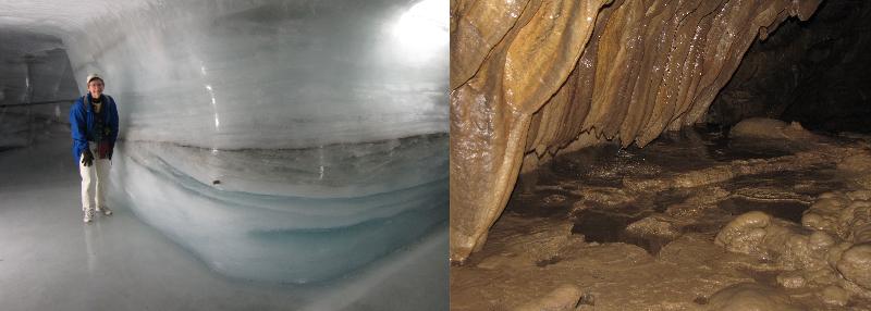
Inside the Jungfraufirn branch of the Aletsch Glacier, Switzerland (maybe like the glacier once in Minnesota!)---.Speleothems in Mystery Cave, Minnesota
Northwest Minnesota and the Story of Glacial Lake Agassiz
Louis Agassiz, after whom the former glacial lake of the Red River Valley was named, was fascinated by the possibility that the world of the past had been quite different from the world of today. In the 1800s, geologists were realizing that earth's past was truly immense and that the world had changed through that immense time. A great debate through much of the 1800s was whether the change happened slowly due to operation of small processes that we see happening today--like the rivers washing sand to the sea-- of whether change happened as a consequence of periodic catastrophes that 'reset' the Earth onto new pathways. Louis Agassiz was a proponent of the later, believing that a past world so wildly different from today as to be covered with great sheets of ice must surely indicate catastrophes of some sort. Charles Lyell's ideas of uniformitarianism with its slow process of change eventually won the day, but Agassiz's contributions to our understanding of Earth's past continue to be significant as we try to understand today how climate can change and thereby change the world.
Louis Agassiz saw evidence that great sheets of ice once covered Minnesota, including the Red River Valley, and that eventually those great sheets of ice gave way to a vast lake far larger than any of the world's present lakes, and that the lake in turn gave way to our present fertile Red River Valley with its crops of grain, potatoes, and sugar beets.
What is the evidence for such a wild story?
To read the stories of the past in the rocks and features of the Earth, we have to have some way to predict how events of the past might have shaped and formed the rocks of the Erath. There are two approaches that we can take to do this. The first is a key concept of historical geology, "The Present is the Key to the Past." We look at modern environments and processes and see what features and sediments we see forming there, and then assume that similar environments of the past would have produceed similar features and rocks. The second approach is to do experiments or simulations in an effort to understand how specific processes might influence features and sediments.
We have already studied how different environments produce different types of sediments: low energy environments of deposition, like swamps or deep lakes, produce fine-grained sediment deposits that become shale; medium energy environments of deposition, like a typical beach, produce medium-grained sediment deposits that become sandstone; and so on.
If we go to a modern glacier in retreat, such as the Mendenhall Glacier in Alaska, we find a poorly sorted sediment--a mixture of fine clay, sand, and gravel--and a landscape that is uneven, rolling, and often poorly drained. This makes sense because the moving ice can carry all kinds of sediment, but will not sort out big particles from little particles. When the ice melts, the sediment simply gets draped across the landscape, making a lumpy, irregular landscape that is not drained by gullies and streams.
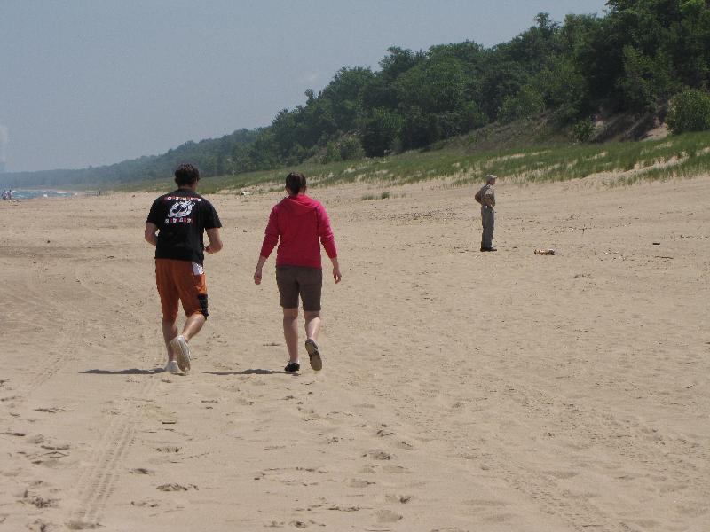
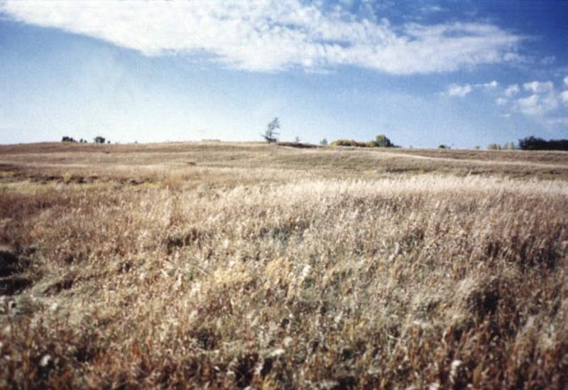
Consider the two images below, both for Northwest Minnesota. Are these images from the glaciated terrane, or the terrane that was once the lake bed of Glacial Lake Agassiz?

In contrast to the rolling, lumpy, and poorly drained topography of the glaciated areas of Minnesota (most of the state) the Red River Valley has some of the most beautiful flatness found anywhere in the world. Although students often think the flatness is caused by the "glaciers scraping it flat like a bulldozer," that is not true. Glacier don't act like bulldozers so much as conveyer belts of sediments. The reason the terrane of the valley is flat is that mud settling from the lake has covered up most irregularities in the former surface.
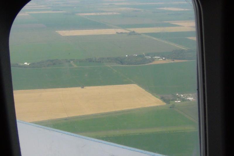
Flat Red River Valley from a plane window.
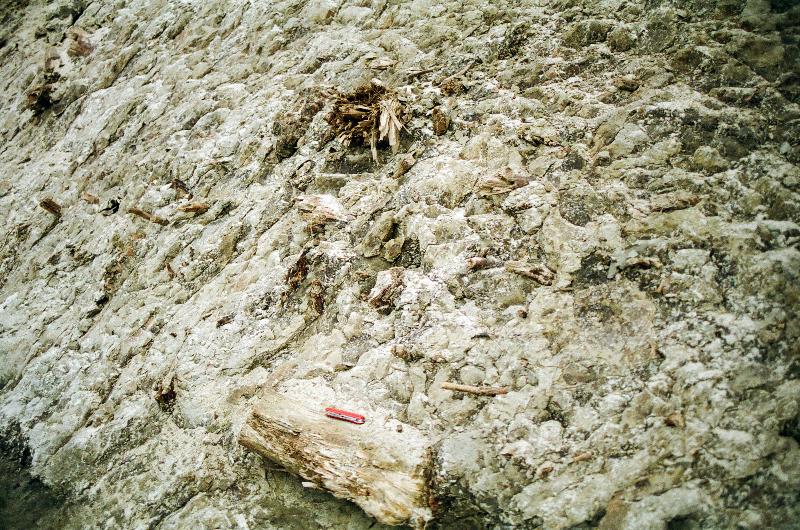
Glacial till can include not only a poorly sorted mixture of clay, sand, and gravel, but even an abundance of tree parts that got caught up in the ice, like the glacial till below from Northwest Minnesota, evidence that the glaciers were once here.
So, what additional evidence do we have to support the idea that the valley was once filled with the former Glacial Lake Agassiz? Based on your understanding of sediment deposition, predict what type of sediment you expect out in the middle of the valley where the water was deep and still, versus the edge of the valley where the waves would have washed against the shore.
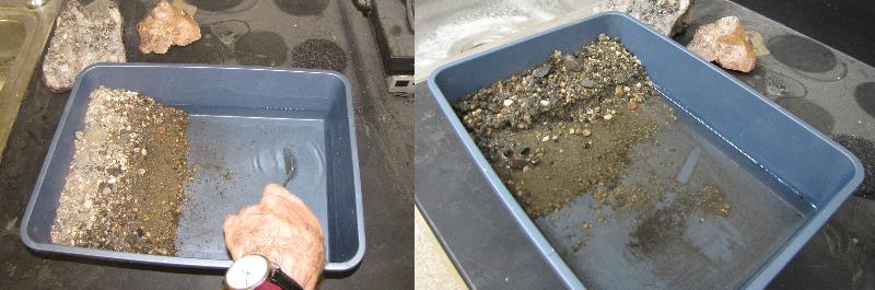
Consider the simple simulation experiment shown below, starting with an unsorted mix of clay, sand, and gravel and a lake with waves. Take a few moments to make key observations about the results of this experiment. Summarize your results.
In the spirit of "the present is the key to the past," we can also look at modern large lakes like we think Glacial Lake Agassiz once was to see what kinds of sediment and features we see at the edge of those lakes. The picture below is a southern shore of Lake Michigan. Can you spot the sandy sediment and the scarp?
So, if there was once a large lake in what is now the Red River Valley, we would expect to find sandy sediment along it and a scarp marking the edge of the lake. The picture below is of a sandy scarp at the edge of the valley east of Moorhead MN.
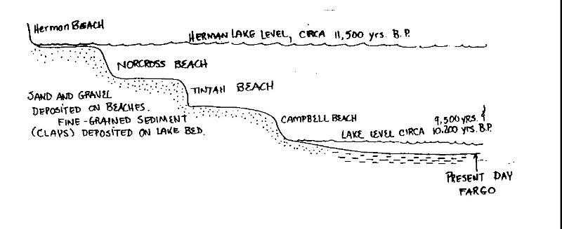
In fact, we can trace several different scarps around the Red River Valley. These have been given names based on nearby railroad towns in MInnesota where those scarps were first described.
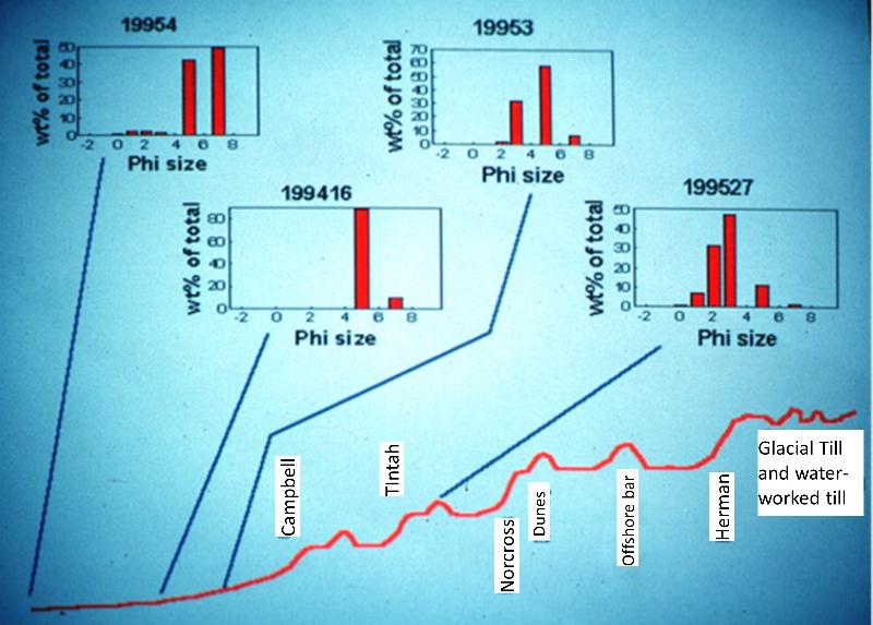
Although we can't stop and feel the sediment, like we could on a real field trip, let's look at the types of sediment that we find along the scarps east of the Red River Valley. First, let's use our concept of "the present is the key to the past," and consider the sizes of sediment particles from a few modern environments. The chart below shows size distribution of sediment as "phi size". On these charts, farther to the right corresponds to smaller sediment--clay sized-- and farther the the left is coarser sediment--gravel. Sand falls in between from about phi size 0 to 4, with 0 being coarse sand and 4 being very fine sand, just barely big enough to see with your naked eye.
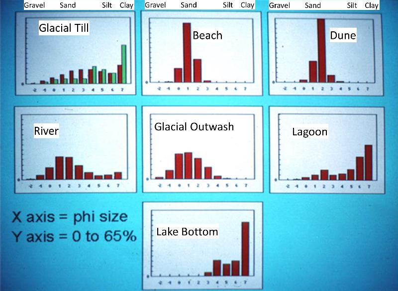
Notice that the glacial till is a poorly sorted mix of gravel, sand, and clay, as we had determined before. Lake bottom and lagoon sediments where we have quiet standing water is enriched in clay-sized sediments. Glacial outwash, as we might expect, looks like glacial till with the finer sediments washed away.
Now consider the samples below from the valley and the edge of the valley at the scarp lines, collected and analzed for size by former students. The squiggly line is a cross-sectional view of the topography from the valley on the left (presumed former lake bed) to the area outside the valley on the right, with the scarps (presumed lake strand lines) in between.
With information about the locations of strand line scarps, sand, and clay sediments (and additional information such as locations of dunes and offshore bars), we can make a paleogeographic reconstruction of the a small area on the eastern shore of Glacial Lake Agassiz near where the modern Buffalo RIver is thought to have flowed into the lake.
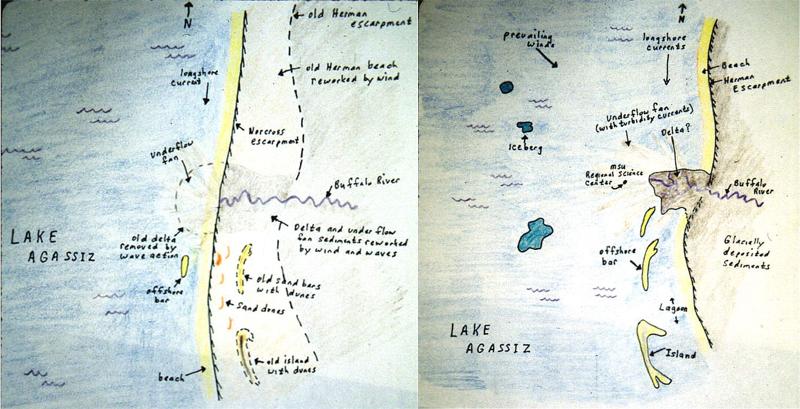
Notice that there are offshore bars portrayed on the map, based on observations of sediments not talked about above. An offshore bar is a ridge of gravel and sand offshore from the beach where storm waves break and a beach-like environment develops. The offshore bar shelters more landward water from the strongest of the lake-waves, thereby creating a lagoon environment. So the area to the east of the bar was likely a lagoon during Herman level times (about 11500 years ago). This ridge probably represents a high area in the glacially deposited sediments that predated Lake Agassiz. As the lake fell, this ridge became first an offshore bar and later the edge of the lake.
Notice also the icebergs shown in the lake for the earlier "Herman" stand of the lake. What might be the evidence that those icebergs actually existed, since they are undoubtedly long ago melted away?
Think about icebergs from today. They contain a lot of rock and sediment picked up when the iceberg was part of a moving glacier.
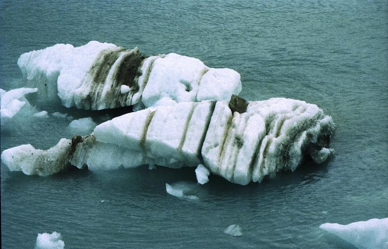
Icebergs in Glacial Lake Agassiz would have dropped sediment into the lake bed as they melted, and some of that sediment would have been much coarser than the clay that normally settled there. Periodically, people find such larger sediment during excavations or construction projects. Boulders that are "floating" in the clay-rich sediment of the valley are called dropstones.
Taking a step back, we can look at a paleogeographic map of the larger area at the time of Glacial Lake Agassiz.
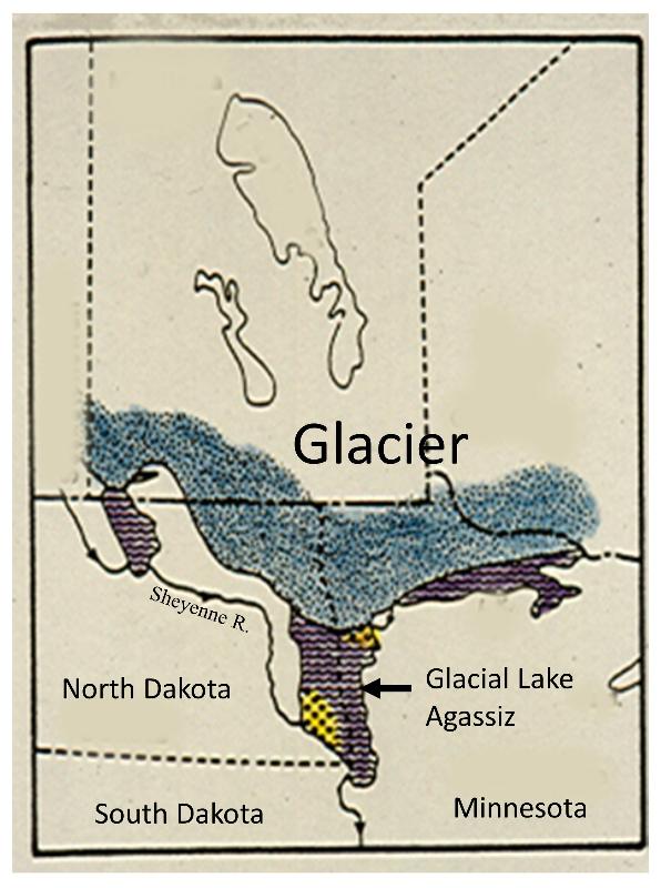
This map shows conditions at a time when the glacier had retreated enough to allow the lake to fill with water, but not retreated so far that the lake drains. The outlet shown in this picture is south of the North Dakota-South Dakota border, near Lake Traverse, flowing into what is now the Minnesota River valley. As the glacier retreated further, the lake expanded, eventually spreading north to what is now Lake Winnipeg.
Given this paleogeography and reasoning, which had to come virst to the southern Red River Valley, the glacier was there first, or the lake was there first? Do we have evidence for this?
The cutbank of the Buffalo River below is about 15 miles east of Moorhead MN, roughly on the Norcross Strand beach. Soil horizons are marked. Soil and sediment are different things--soil is a material that is developed in place (without significant transport or deposition) by organic and inorganic chemical activity. Sediment is a material that has been transported and deposited and tells the story of an environment of deposition. The holes in the B horizon are swallow nests! See if you can spot and differentiate the layers of sediment that occur below the soil layers. Then notice the graphs that show the sediment size and character (sediments collected and analyzed by previous students). What types of depositional environments do they represent and what is the sequence in which those environments occurred at this spot long ago?
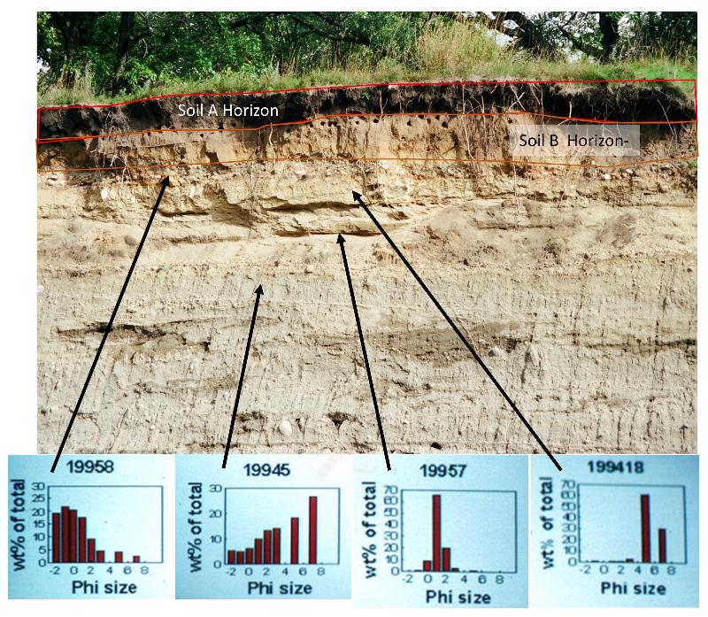
Notice the darker patches in the bluish lower glacial sediments in the cutbank picture above. These are actually damp areas in the sediment, the dampness making them appear darker. The dampness suggests that water is seeping out of these areas. Seeping water suggests that these sediments are more permeable than surrounding sediments (permeable means that liquids, like water, can seep through them). Clay-rich glacial till is extremely impermeable, so the permeable nature of these patches of sediment suggest that they are more sandy--and less clay rich--than surrounding sediments. What might cause those sediment to be sandier and how could a sandy layer get right in the middle of the glacial till? Was there river or beaches while the glacier was still here? Did the glacier go away and then come back?
This effect is even more pronounced a short distance away in this same cutbank, as seen in the picture below. Sediments were collected and analyzed by previous students.

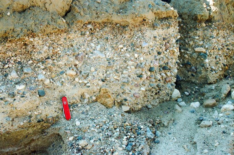
Glacial till with its abundance of clay and its poorly sorted mix are not good for construction gravel (because the undesirable clay is difficult to separate from the sand and gravel component) and is also not good for ground water resources (because the clay makes the sediment impermeable, so water can't move through it). Making gravel deposits and ground water aquifers, two important resources in NW Minnesota, requires that past geological processes has washed out the fine clay particles from the glacial sediment by running water. The illustrations below show how this can happen.
Gravel deposits in a Northwest Minnesota gravel pit, formed by washing the fine sediment out of the glacial till.
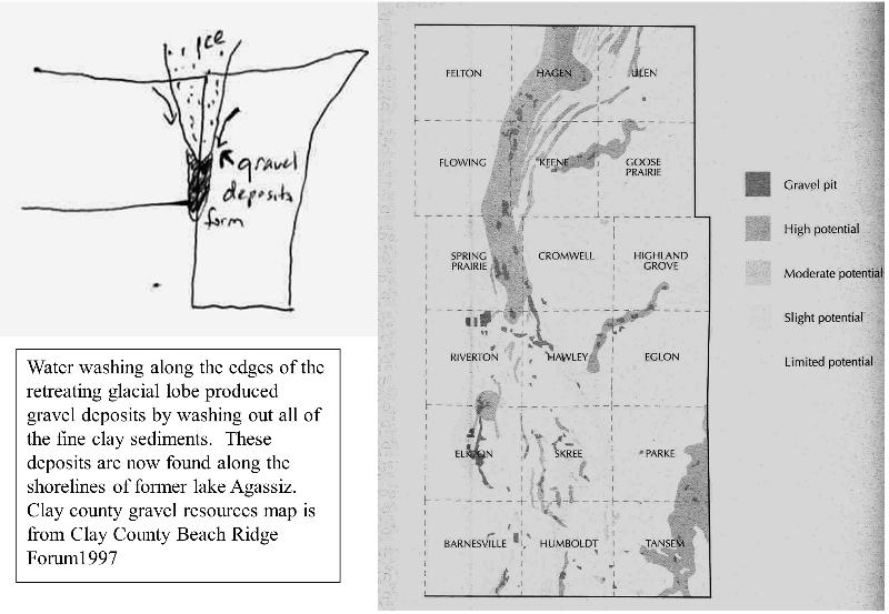
Below is an illustration of the model for the development of the Buffalo Aquifer, a major water source for Moorhead, MN for many years. The Buffalo Aquifer was also quarried for gravel up-flow from the Moorhead wells--an obviously problematic choice.

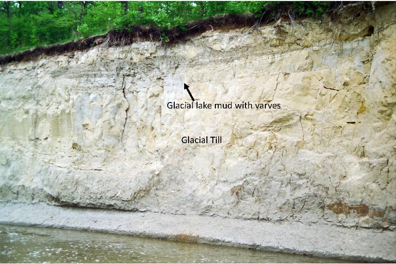
Sometimes students ask why, if there was once a lake here, don't we find fish fossils in the mud of the Red River Valley. We can answer the question by thinking again of "the present is the key to the past." Modern glacial lakes are mostly devoid of life, and thus we would not expect a lot of fossils to be preserved in the lake mud of Glacial Lake Agassiz, either fish or invertebrates like gastropods (snails) or pelecypods (clams). Modern glacial lakes often freeze over in winter, moslty halting the influx of sediment and then open up in the summer allowing sediment to wash in. This creates a seasonal variation to the sediments coming into the lake that can show up as alternating layers of sediment called varves. We can observe varves in the sediment deposited at the edge of Glacial Lake Agassiz, as seen in the pictures below from near Twin Valley, in northwest Minnesota.
The MInnesota River Valley and a Journey into Deep Time
Some of the oldest rocks in the world are exposed at the surface of the Earth in the Minnesota River Valley where the Amazon-River-quantities of glacial melt water from Glacial Lake Agassiz once flowed.
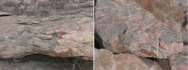
Metamorphism happens in the deep roots of mountain ranges where temperatures and pressures are high, causing rocks to change form (meta-morph) giving new textures and different minerals. By looking at the types of minerals that form and their chemical composition, we can determine what the pressure and temperature must have been when the rock formed. The pressure and temperature of these rocks suggest that they were once buried as much as 75000 feet beneath the surface, corresponding to a towering mountain range 20000 to 30000 feet high (Mount Everest in the Himallayas is about 29000 feet).
Since these towering mountains are now completely gone, these rocks tell not only the story of a mountain range that once existed in Minnesota, but also tell the story that that mountain range must have eroded away!
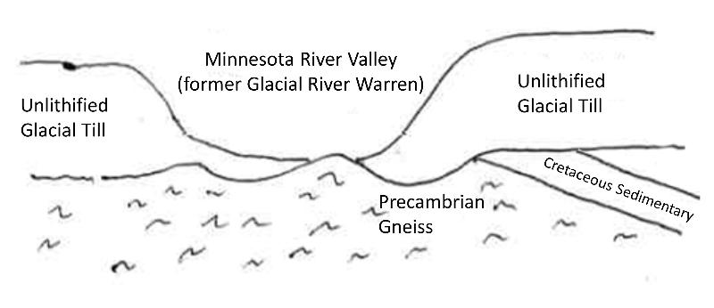
A cross-sectional illustration of the relationship between the overlying glacial till, the underlying gneiss, and the Minnesota River valley, is shown below. This type of boundary--where there is a 'time gap' between layers in contact with each other--is called an unconformity. This particular type of unconformity, in which unlayered igneous or metamorphic rocks are in contact with layered rocks, is called a nonconformity.

Using radiometric dating techniques, M. E. Bickford (my very first geology professor!) and others have estimated an age for the gneiss at 3.49-3.55 billion years, among the oldest rocks on Earth!
There are also some outcrops, mostly on the western edge of Minnesota, of marine Cretaceous sedimentary rocks. Those are included in the cross-section below. The boundary between the Cretaceous rocks and the till is a different kind of unconformtiy called an angular unconformity.
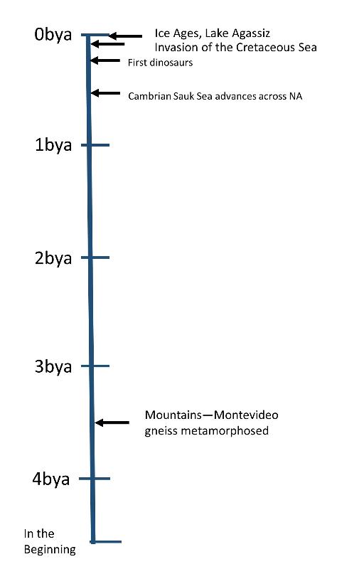
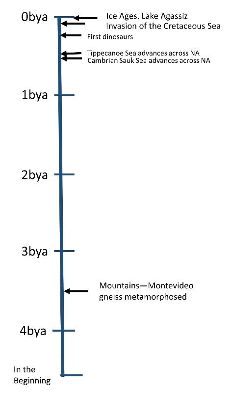
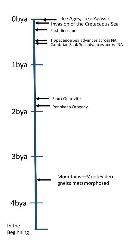
Consider the time line below to get a feel for how ancient the Montevideo gneiss truly is. Remember, all the coming and going of mountains and seas that we talked about in our lesson on Paleogeography of North America has to fit into the little time between the advance of the Sauk Sea and today! (And a great deal more happened during this time that we didn't talk about in the Paleogeography lesson)
(bya = billion years ago)
So how do we know that the glacial till of the bluffs to either side of the Minnesota River Valley really is glacial till? It's nice to name it on a cross-sectional illustration, but what is the observational evidence?
Clue 1: It is a poorly sorted mix as is also true for till deposited by modern glaciers. See the picture below from a gravel pit on the side of the river channel near the exposures of the gneiss. Notice the find gray sediment indicative of clay, and also the gravel and boulders.
Clue 2: In the picture above, also notice the flat top to one of the boulders. This is a glacier-faceted boulder. As ice with imbedded gravel, sand, and silt moved over an area (if ice isn't moving, then we don't call it a glacier), it acts like sandpaper, scraping and polishing underlying rocks. This creates common faceted boulders like that seen above.
Clue 3: The scraping and polishing of the moving ice also creates lots of rocks with linear scratches (called glacial striations) and sometime random scratches as the rock gets turned in different orientations as the ice moves over it (called chatter marks). The picture below is from a student who found a hard chert sample with both striations and chatter marks at the gravel pit on the edge of the Minnesota River Valley (thank you to student Sarah Smart for this image).
Clue 4: The pieces of rock that are found in the till layer, and also large boulders that are lying out in fields, don't match-up with the underlying types of rock. In other words, they have been brought from someplace else. A glacier, which is a moving sheet of ice with sediment embedded in it, offers a mechanism by which those materials could have been transported to this area. Large boulders lying at the surface that don't match the underlying rock type are called glacial erratics. A glacial erratic from the Minnesota River Valley area is shown below.
At the time that the glaciers were in retreat, and glacial melt water was pouring out of Glacial Lake Agassiz into the Minnesota River Valley, the amount of water was much greater than what the modern Minnesota River carries, perhaps comparable to the water carried by the modern Amazon river.
How do we know this?
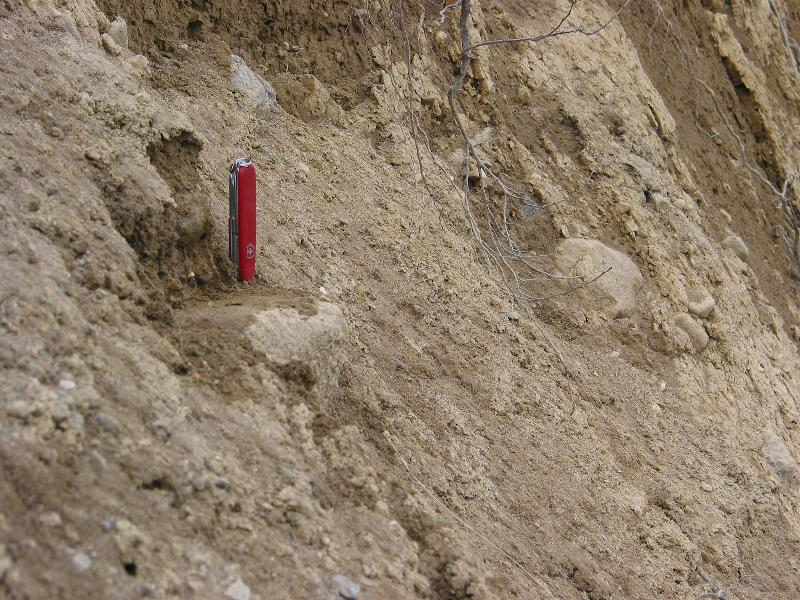
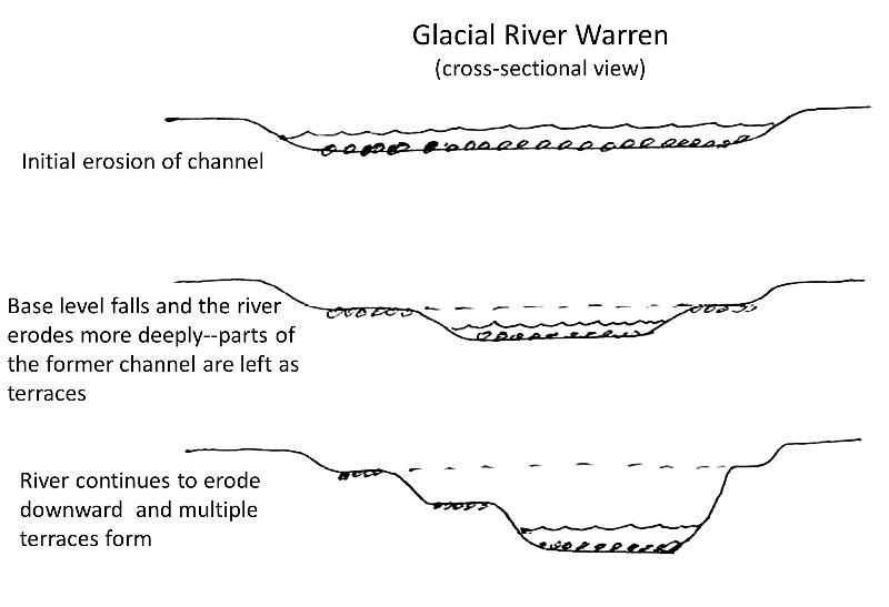
One clue is that the Minnesota River Valley is in fact a former river channel--not like a river valley that has formed over time by a meandering channel that gradually widens its valley. The fact it is a channel is reflected in it shape--more channel-shaped and not like a flat floodplain. Also, the big valley has terraces on the edges that show where the water level was at different times as the water gradually eroded down through the glaical till. Terraces are flat areas that form by erosion or deposition and mark a base level for the river in the past. These terraces are illustrated in cross-sectional view below and can be spotted along the edges of the Minnesota River valley and recognized by their flattish surfaces (although often dissected by more recent streams that have eroded down through them). Sometimes terraces can be matched up from one side of the valley to the other. These terraces also tell us that this is a former channel, not a flood plain.
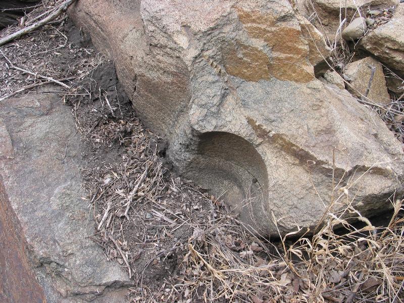
Another clue that River Warren was a much larger river than the modern Minnesota River is that features of river erosion are now found in the Montevideo Gneiss far above where the modern river reaches even during flood. One such feature is the presence of stream-polished rock and potholes. Potholes form when water rushes over rock and causes sand or gravel to swirl in a particular spot. This swirling action can act like a drill, boring a smooth, round hole down into the rock. We see these in modern stream in rocky channels. A partial pothole in the Montevideo Gneiss in the Minnesota River Valley is seen below. The remainder of the pothole has presumably eroded away, probably while RIver Warren was still flowing.
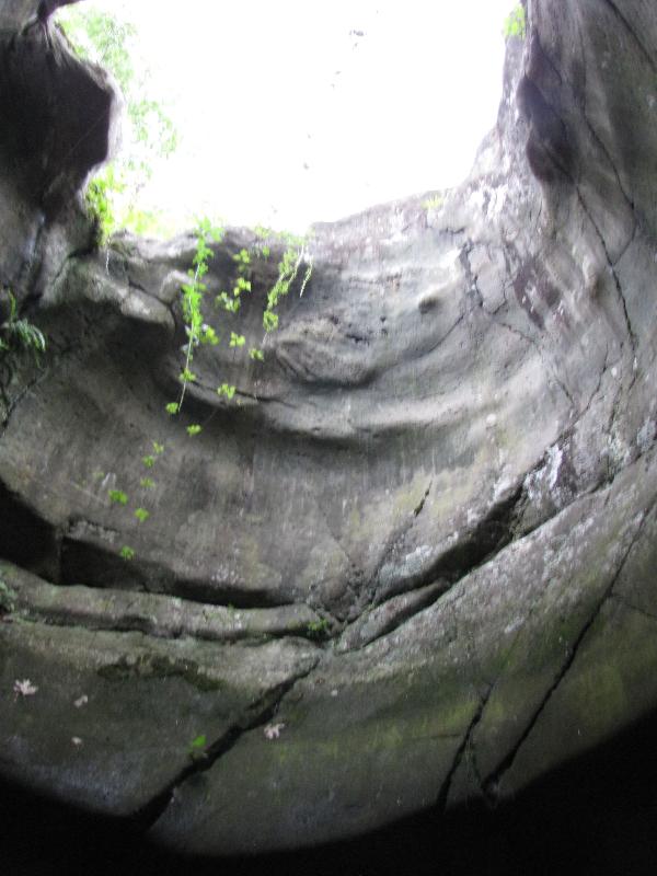
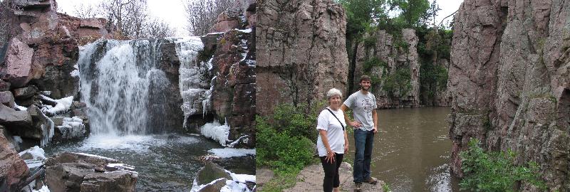
Other rivers in Minnesota also carried a great deal more water in the past when the glaciers were melting. For example, the St. Croix river in eastern Minnesota against the border with Wisconsin once carried the meltwater flowing from Glacial Lake Duluth. Water rose high up on what is now the valley walls of the Palisades in Interstate park. This water drilled some of the largest potholes known in the world. See the pictures below!
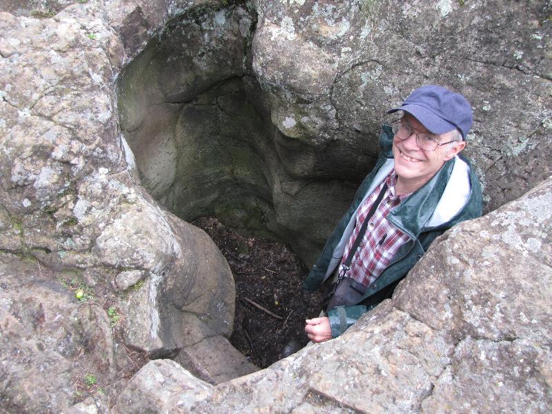
Above: Your professor in one of the Potholes along the St Croix river in eastern Minnesota
Below: Peering up out of one of the deepest potholes known on Earth in Interstate Park, eastern MInnesota.
Southeast Minnesota and the Story of the Tippecanoe Sea
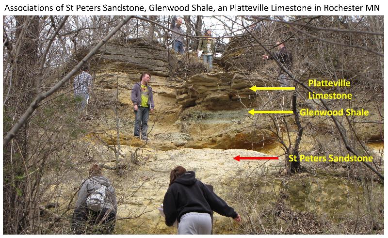
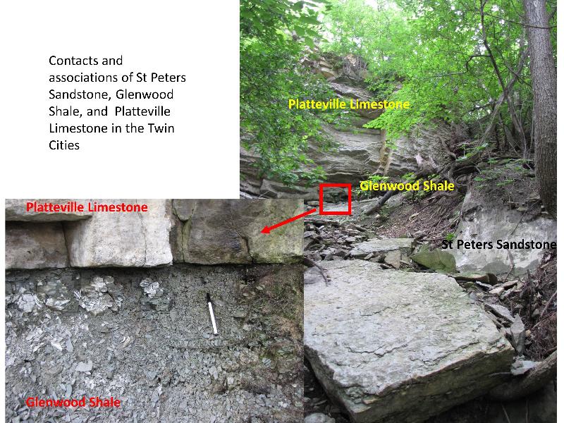
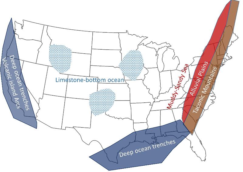
Southeast Minnesota is mostly south of the area where the geologically-recent glacial till covers up the older rocks. This region is underlain by rocks of Ordovician age (early Paleozoic). Some of these rocks outcrop in both the Rochester area and the Twin Cities area, as shown below. Based on stratigraphic principles from previous lessons, what story do these sequences of rock tell us?
The advance of the Tippecanoe Sea during the Ordovician Period of the Paleozoic has been added to the timeline below. Notice how on this scale, which shows the whole history of Earth, the Tippecanoe Sea and the Sauk Sea seem close together. In reality there is vast time between these events.
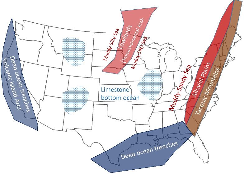
After the initial advance of the Tippecanoe Sea, there was an extended period of time when highly fossilferous limestone and shale were deposited in southeast Minnesota as the sea covered most of North America. However, the Transcontinental Arch, which cuts down through Minnesota, was periodically exposed and then covered by the sea again, as shown in the paleogeographic maps below. This exposure and resubmergence of the arch may have happend over and over many times, although southeast Minnesota, and most of the central continent, remained mainly marine. (The Transcontinental Arch is the same arch that was the last to be covered by sea during the advance of the Sauk Sea in the Cambrian that we examined in our last lesson)
Ordovician Time Period:
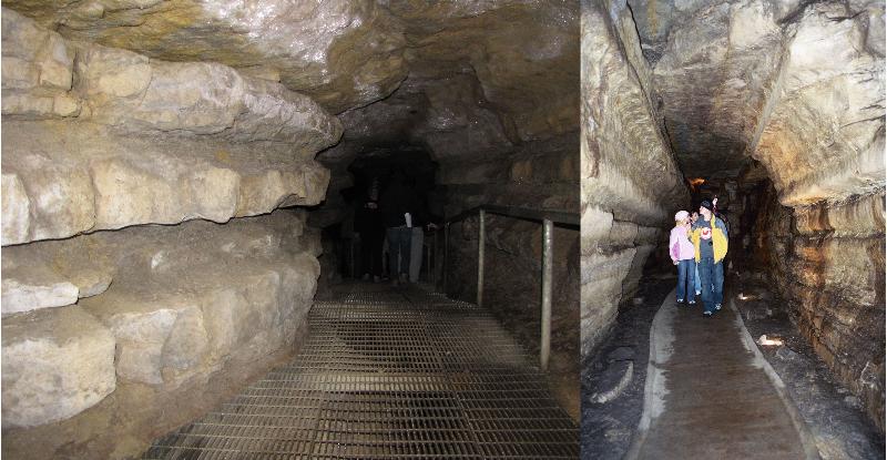
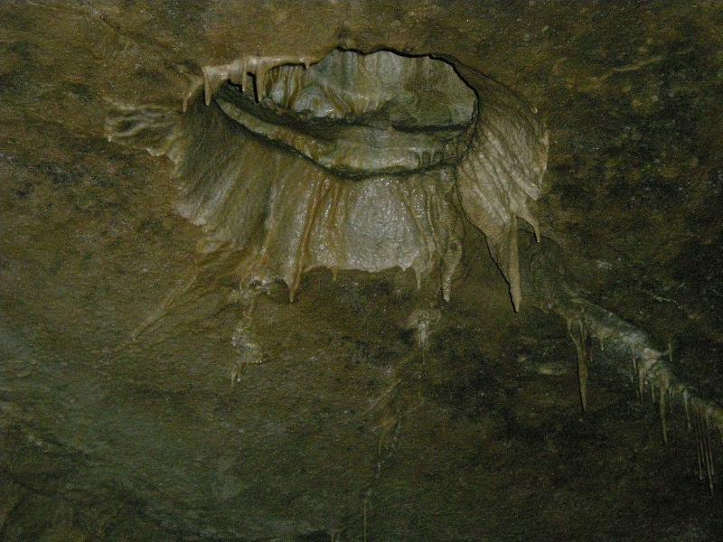
Below is a picture of the Dubuque Formation exposed inside Mystery Cave in southeast Minnesota. The Dubuque Formation is one of the many limestone and shale deposits formed after the advance of the Tippecanoe Sea. The more resistant rock layers are Limestone while the shale layers are more crumbly and wash away more easily inside the cave. Does the appearance of this rock layer support our paleogeographic interpretation above (yes, it does--explain how it supports it to yourself or someone else)?
Here's a cross-cutting relationship problem for you: Which came first, the Dubuque Formation was deposited, or a cave was formed in it?
Right. You have to make the rock first before you can make a cave in it.
Caves in limestone form after the limestone is raised up above sea level, and acidic water trickles through it, dissovling the limestone. At first, the process widens joints and fractures in the rock, but eventually larger chambers and corridors can form as more and more limestone is dissolved.
The picture below shows a 'beginning' stage of wideing of joints in limestone prior ot major cavern formation (this picture is from the Aran Islands in Ireland). Notice how the solution-widened joints make a pattern that is typical of stress-induced fracturing and jointing in rock. The pattern of the caverns at Mystery Cave in Minnesota follows a similar joint pattern, with passageways often making 60 degree and 120 degree angles reltaive to each other.

The reaction for dissolving limestone is simplified as the following:
CaCO3 + H+ → Ca++ + HCO3-
where the CaCO3 is calcite, the main mineral in the rock limestone, H+ is hydrogen ion, the ingredient that makes water acidic, and Ca++ + HCO3- are dissolved components in water.
In understanding this reaction, i's important to know one of the key concepts in chemistry, the Le Chatelier Principle. In simplified form, this principle is that if we increase the chemical activity (concentration) of one of the chemical components on one side of the reaction or the other (one side of the arrow), it will cause the reaction to shift in the other direction, toward the other side of the arrow. Often, a major contribuitor to acidity in water is carbon dioxide (CO2) which forms carbonic acid--more CO2→ more H+→ more acidic. With this information, think about the following problems
Often the water in Mystery Cave is close to saturation with respect to CaCO3. The high concentrations of CaCO3 in the water is part of what gives Turquoise Lake is striking blue color (the picture below is courtesy of former student Sarah Smart).
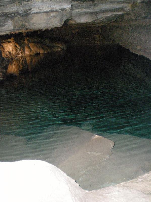
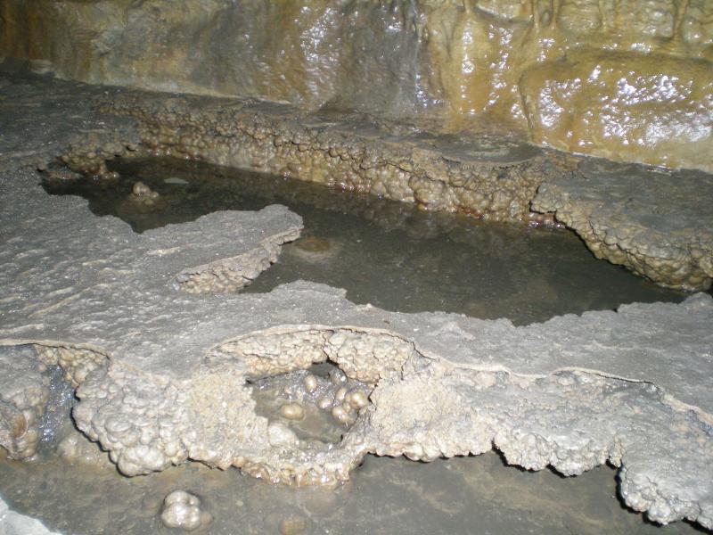
Precipitation right at the water line also suggestions saturation, with precipitation occuring at the water line because that is where evaporation of carbon dioxide (and also water) occurs. In the picture below, also from former student Sarah Smart, you can see that the previous water table in this part of the cave was different in the past. Did it rise or fall? Also, is there evidence that some precipitation does indeed take place below the water level?
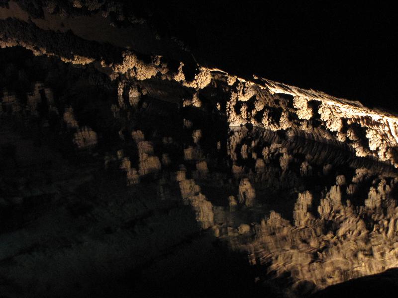
Smooth cave features often form where water flow is high, so that precipitation of limestone is distributed over the feature. Rougher feature, like helictites often have lower water flow so that the carbon dioxide evaporates quickly and the limestone precipitates unevenly.
Which of the following cave features suggest higher flow volumes and which lower flow volumes?
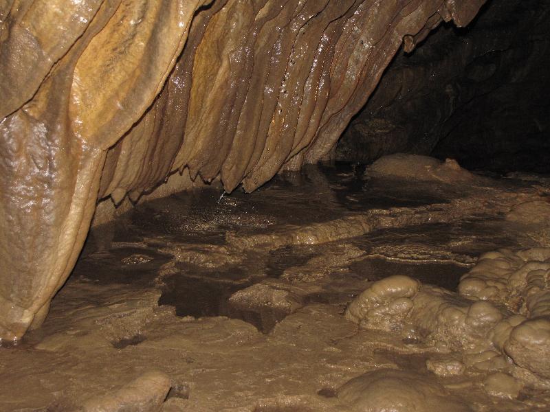
The feature below (from former student Sarah Smart) is one of Mystery Cave's more unique features--round holes in the roof of cave chambers. Based on what we have learned, try to identify a model that is a reasonable explanation for their formation.
The dissolving of limestone underneath a landscape also has a significant affect on the landscape itself. Karst topography is a term for a landscape in which sinkholes have developed where water has dissolved enough limestone to make a cone-shaped depression. Water runs down into the cave at much faster than a trickle in these depressions. In a Karst terrane,rivers can disappear as water pours into underground caverns.
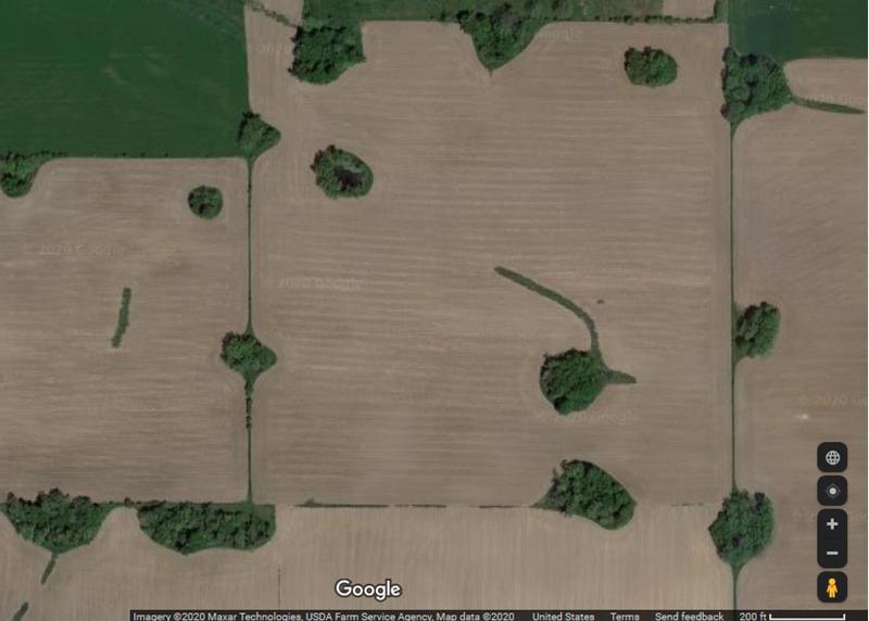
These sinkholes provide an inlet to the underground water that can allow pollutants to be readily introduced. In the past, people often used sinkholes as dump sites because whatever you threw in them would eventually disappear. Needless to say, this was not an environmentally-friendly practice. Below is a Google Maps image of the Karst terrane in Southeast Minnesota, showing several tree-filled sinkholes.
Southwest Minnesota and an Ancient Alluvial Plain?
The farther we go back in time, the fewer rocks are left to tell the stories of that vanished era. Erosion is always erasing the stories even as they are written. For the most ancient stories, the eraser has been running for a long time and we we only get small glimpses of the story, like a page or two of a great novel.
The rocks of the Sioux Quartzite are particularly resistant to weathering and erosion. Being "supermature" means that it is made almost entirely of quartz, the most stable of the major minerals at the surface of the Earth. Being metamorphosed has bonded the quartz grains together to further resist erosion. This resistance to erosion is why the Sioux Quartzite makes such dramatic waterfalls and cliffs in southwest Minnesota. It is also part of why the Transcontinental Arch has been a high region in the continent since ancient times (for example, often the last to be covered by sea during the marine transgressions of the early Paleozoic).
Even when rocks have survived the eraser of time, the most ancient rocks may lack clues that might help us tell its story, clues like fossils which, although abundant in the Paleozoic, are much more rare in the preCambrian. Land fossils are completely absent in the most ancient rocks like the Sioux Quartzite.
Thus, the story told by the Sioux Quartzite of southwest Minnesota is an uncertain one. Even its age is uncertain, since we can't get an age with fossils, and a supermature quartzite (a metamorphosed sandstone) is not well suited to radiometric dating. However, based on igneous rocks above and below, which we can date, we put its age between 2.28 billion years ago (bya) and 1.12 bya. By correlating the rock stratigraphically to other regional rock layers, we get a narrower age range of around 1.7bya. What story does it tell us of what the world was like back then?
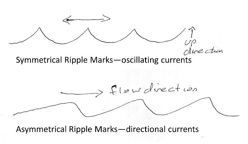
Was the sandstone deposited in rivers, dunes, or along the beach of an ancient sea? We aren't completely sure, and maybe some of each of these happened, depending on what part of the unit we are looking at, but some parts of the Sioux Quartzie we can figure out by considering ripple marks. Symmetric ripple marks often form where water oscillates, such as waves sweeping up a beach and back. Asymmetrical ripple marks often indicate flowing water (or wind), and can even tell us the direction of flow. A cross-sectional view of each type of ripple is shown below.
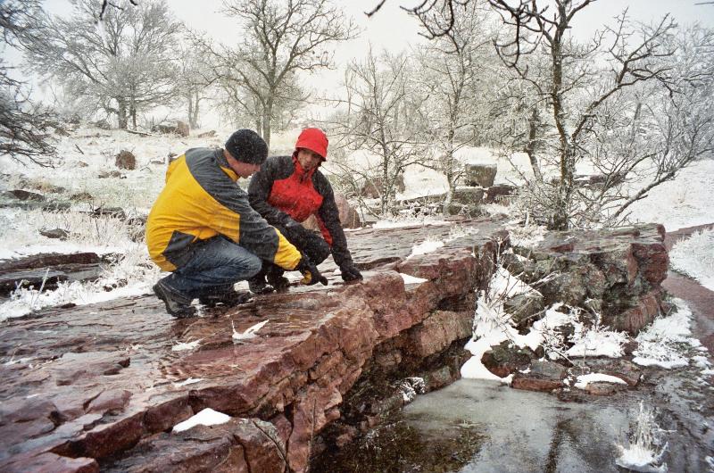
Here are some ripple marks from Pipestone NM. What do they tell you?

The sandstone that was metamorphosed to make the Sioux Quartzite is supermature--meaing that it is almost entirely quartz, the quartz grains are well rounded and for the most part well-sorted. These characteristic are unusual for river depoosits--rivers tend to not round or sort grains as well as beaches or wind dunes. The supermature sandstones that we have talked about before, including the sandstone at Wisconsin Dells and the St Peters Sandstone, are thought to be beach and/or dune sands. So something is unique about the Sioux Quartzite depositional environment. Interestingly, it is not unique to its time period--similar quartz-rich standstone from this time period occur across the Minnesota-Wisconsin region. For example, the Baraboo formation in central Wisconsin is a similar and correlated unit. What was different back then? Well, one difference is there was no land plants, or other land life, at the time, which might have affected the behavior of rivers and erosion.
Even so, we can make some conclusions about the depositional environment. Based on what we have learned in previous lessons about environments of deposition, what does the supermature sandstone tell us about these rivers and the deposition in them?
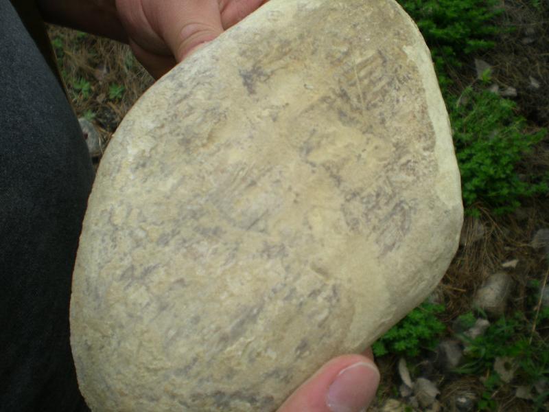
There is variation in the type of sediment in the Sioux Quartzite. For example, some parts of the unit, particularly lower in the stratigraphic column, are coarser and conglomeratic. There are other units that are much finer grained, implying standing water bodies in the system of rivers. The Pipestone deposits (also called Catlinite) are fine-grained claystones that represent these lower energy environments. Native Americans of the past used the pipestone to make pipes and also other artistic and utilitarian objects because they recognized its properties of being strong, not brittle, and soft, making it easy to carve.
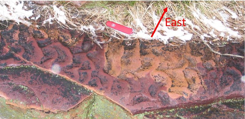
During the ages that have passed since the deposition of the sandstone that became the Sioux Quartzite, a lot has happened. The rocks got metamorphosed and also tilted. In the picture below, east is roughly to the left in this picture, indicating the rocks are dipping toward the east.
The place in time for the deposition of the Sioux Quartzite, in Minnesota's immense timeline, is shown below, along with the Penokean Mountains which we will be our first topic of study in Part 2 of our lesson.
last updated 4/27//2020. Images from other sources, such as from student field trip participants ,are indicated in the text. Other text and pictures are the property of Russ Colson.