Landscape Review, Human Impacts
Earth Science Extras
by Russ Colson
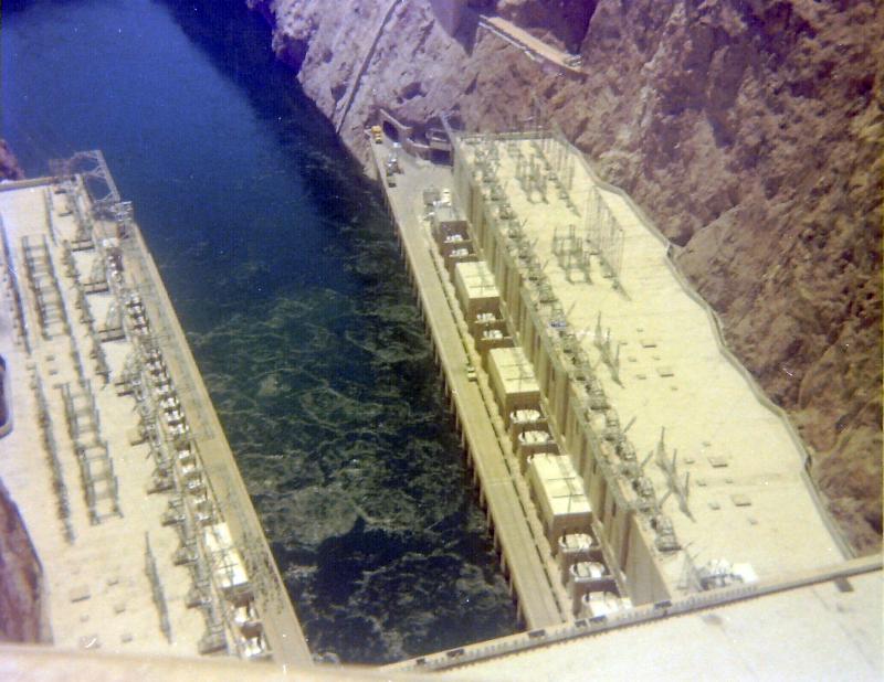
Looking downstream from Hoover Dam (picture was taken when I was there in 1976, explaining the somewhat color-faded image!). The turbine buldings, where the electrical power is generated, are seen on the left (Arizona side) and right (Nevada side). Turbulence where the water emerges from the turbines after dropping 500 feet down the intake towers on the other side of the dam, is seen in the roiled water of the river.
Thinking about human impacts:
Take some time to consider the broad human impacts on landscape and environment and the impacts of landscape and environment on humans. Make a list of each: Impact of humans and impact on humans. Find someone to talk with about this, brainstorming as many ideas as you can about the possible consequences of human activities on landscape and environment as well as how landscape and environment affects human activies and commerce. Come up with at least 5 things in each category, jotting down some of the implications of each thing, or how they might occur, or how you know they might occur.
Try to make some predictions:
Let's now focus on a more specific impact question: How does building a dam on a river affect the landscape, and us? As you did above with the broader question of human impacts, take some time to consider the impact of dams on landscape and the impact of dams on humans. Again, make a list of each: Impact of dams on landscape, impact of dams on humans (feel free to also include how landscape affects where we might build dams). Again, find someone to talk with about this, brainstorming as many ideas as you can.
Examination of an Example Question: How do Dams affect sediment downstream?
A broad awareness of how humans can impact our landscape, and how the landscape can impact us, is of course important. However, it is also important to have some idea about how we know that these impacts are real and how significant they might be over time--and that requires a lot more study and thought than simply engaging in speculative brainstorming or conversation. We are going to examine more deeply a narrow aspect of how dams affect the landscape and us, focussing on the impact the dam has on sediment deposition and erosion on the river. This exercise is going to be presented mainly as a graph-reading exercise (an important practice of science), with data and graphs taken from the United States Geological Survey Professional Paper 1286, Downstream Effects of Dams on Alluvial Rivers by Garnett P. Williams and M. Gordeon Wolman, 1984.
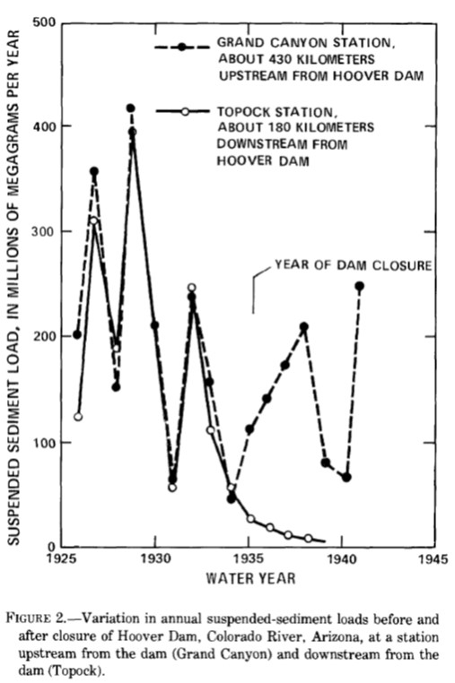
Consider the graph below from Williams and Wolman. What does it tell you? Be sure to examine the labeling on the axes, read the caption, look carefully at the data, and think about what it means.
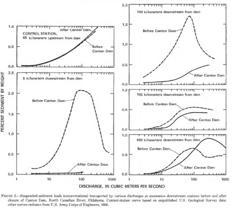
Consider the graphs below showing sediment load near a different dam. Notice the difference in what is plotted on the x and y-axes.
Think Questions: So, if the sediment in the river immediately downstream of the dam is greatly decreased, where do you suppose all of the sediment is going that used to go down the river there?
Does your interpretation make sense?
What landscape feature forms where sediment-laden rivers flow into a standing body of water?
Notice the delta formed where the Colorado river flows into lake Mead, (the delta in this picture is revealed by the extreme drought in the Southwest United States during this time which dropped the lake level). Picture from article in the ListWire, "Dramatic images of the drop in Lake Mead water level over one year," by Rick Suter July 21, 2022 9:21 pm ET;https://thelistwire.usatoday.com/lists/dramatic-images-of-the-lake-mead-water-level-over-one-year-hoover-dam-colorado-river-california-drought/

More muddy sediment in the former bottom of Lake Mead, exposed by the extreme drought of the 2000s. Image from The Washington Post, 'Where there's bodies, there's treasure': A hunt as Lake Mead shrinks" By Joshua Partlow Updated June 28, 2022 at 12:43 p.m. EDT|Published June 28, 2022 at 12:36 p.m. EDT https://www.washingtonpost.com/climate-environment/2022/06/27/lake-mead-reservoir-drought/
Think Questions: If sediment load is decreased by more than 90% as indicated in the graphs above, what implications will this have for the river downstream? How might this affect point bars, river erosion/deposition rates, river channel width?
What are the implications downstream from a dam if the % sediment in the river right below the dam is greatly decreased, but sediment load farther downstream is effected less? What does this mean must be happening to sediment in the river bottom below the dam?
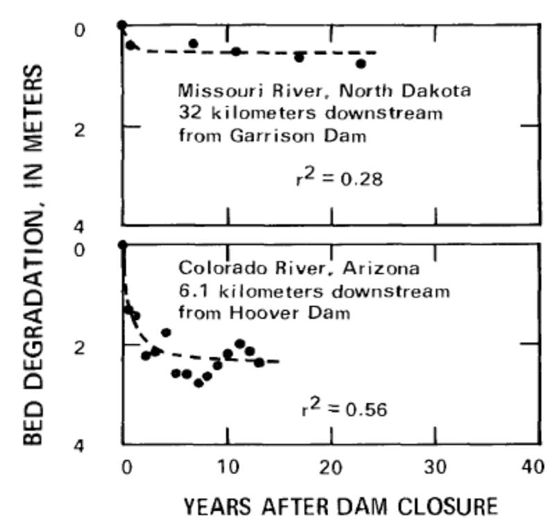
Consider the graphs below to see data that address one possible prediction (bed degradation refers to erosion of sediment from the bottom of the river).
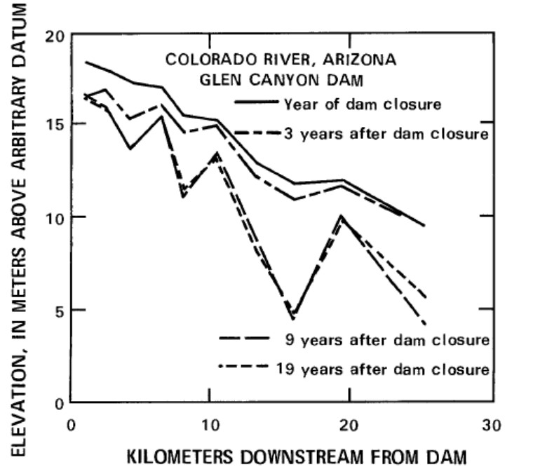
The graph above does not give us information about how the degradation of the river bed changes with distance downstream, but the graph below does provide that information. Think about what it means.
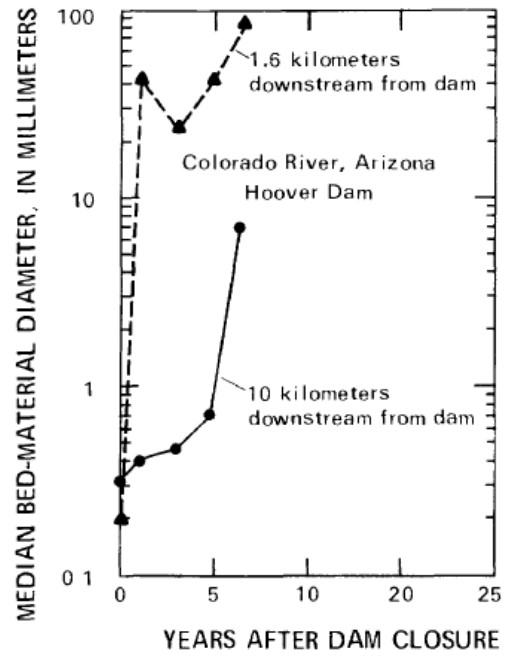
Think Question: If the stream bed is being eroded downstream from a dam, how do you expect the average size of sediment particles to change? Why do you think that?
Check out your answer in the data shown in the graph below.
Think Question: So where does all that sediment go, and how long will it take to completely fill in a reservoir with clay, silt, sand, and gravel?
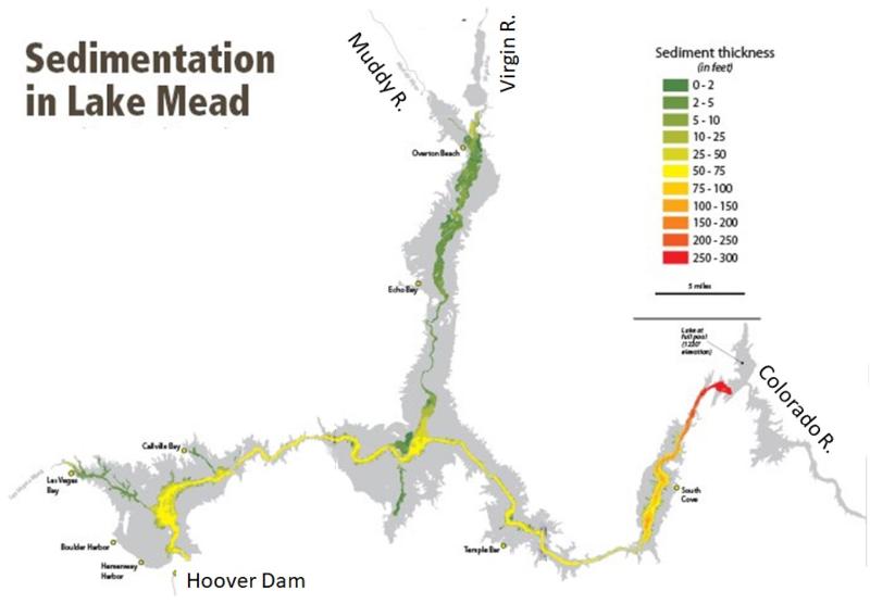
Consider the map below from National Park Service, Lake Mead National Reservoir, "Sedimentation of Lake Mead," based on surveys from 1999 to 2001, https://www.nps.gov/lake/learn/nature/sedimentation-lake-mead.htm
The sedimentation rate in Lake Mead has not been steady through time. Study the table below. When did the sedimentation rate change most significantly?
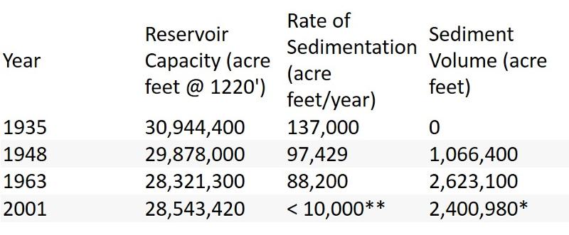
Think Question: What might cause the change in sedimentation rate after 1963?
Another dam, upstream of the Grand Canyon and thus upstream of Lake Mead, was completed in 1963 (The Glen Canyon Dam)! Based on what we have looked at in the graphs above, how would this change the amount of sediment being transported by the Colorado River into Lake Mead? (you can figure this one out!)
Getting back to our earlier question of thinking about how long it will take for Lake Mead to fill up with sediment:
last updated 8/16/2022. Text and pictures are the property of Russ Colson, except as indicated.