Case Studies in Petrology: Igneous and Sedimentary
Earth Science Extras
by Russ Colson
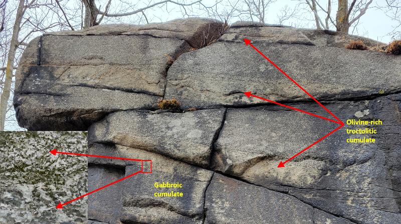
Boundaries between coarser-grained gabbroic cumulate and finer grained troctolitic (olivine-rich) cumulate in the cyclic zone of the Duluth Layered Intrusive, Duluth MN. Background photo is courtesy of Haley Tyler, 2022.
Igneous Case Study: The Duluth Layered Intrusive
Introduction:
The main focus of our examination of the Duluth Complex will be on the chemical signatures of the geochemical differentiation of the complex. Geochemical differentiation refers to the way by which an originally homogeneous Earth becomes differentiated (made different) through partitioning of chemical elements between solid and liquid phases and the subsequent physical separation of those phases, creating regions of differing composition. Chemical composition is thus a signature or fingerprint of the processes that a particular rock has experienced. Differentiation processes can include crystallization processes in which minerals crystalllize from a magma and become separated (such as by density settling). The crystallization might be equilibrium (where the crystals continually re-equilibrate with the remaining liquid), or fractional (where the crystals are removed in some way, either physically or because of limitation of diffusion, and do not re-equilibrate with the melt). Another process of differentiation might be partial melting, in which a rock partly melts, with elements partitioning between the liquid and solid remainder. This might again be either equilibrium (with the melt and remaining solid maintaining a chemical-equilibrium) or fractional (where each increment of melt is removed from the solid such that it can't continue to reequilibrate). There are many other considerations for differentiation processes, such as mixing between different magma bodies, assimilation of surrounding rock by a magma, multi-step differentiation of various sorts where the rock derived from a previous step becomes the starting point for a new process, or partitioning between different immiscible melt phases in contact with each other. In all of these processes, conditions of temperature, pressure, and initial composition of the phases affects how elements partition.
For simplicity, we can think of two types of elements: compatible and incompatible. Compatible elements are those that, under certain circumstances, tend to partition into the solid phases. Incompatible elements are those that, under certain circumstances, tend to partition into the liquid phase. We can understand these two mathematically by considering the idea of a partition coefficient:
Partition coefficient = D = Concentration of the element in a solid phase/concentration in a liquid phase
Compatible: D>1
Incompatible: D<1
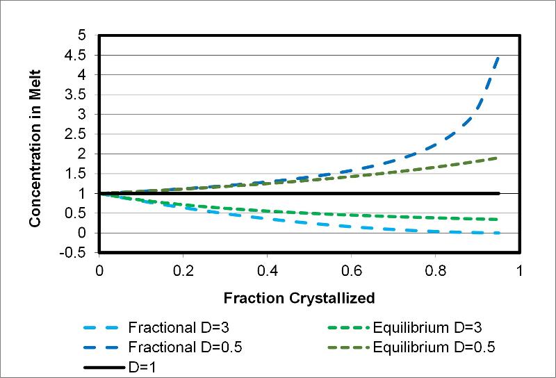
If we consider a situation in which the value of D stays relatively constant (probably never perfectly true but we can often understand the chemical evolution of a complex system by making this assumption) then the concentration of an element in residual liquid after equilibrium crystallization of some amount of solid can be described by the expression:
Cl = C0/(D-D·F+F)
Where C0 = the initial concentration of the element before crystallization begins,
D = the partition coefficient for the element under the conditions of crystallization
F = the fraction of melt remaining after some period of crystallization
and
Cl = the concentration of the element in the melt after crystallization
A analogous equation for the case of fractional crystallization would be the following:
C=C0 F(D-1)
From these expressions, we can predict the way that concentrations of an element will change during crystallization for different values of D and F, as shown below (in this chart, C0, the initial concentration, is taken to be "1", such as 1 part per million = 1ppm). Note that fraction crystallized = 1- fraction melt remaining.
Duluth Complex--Chemical Trends
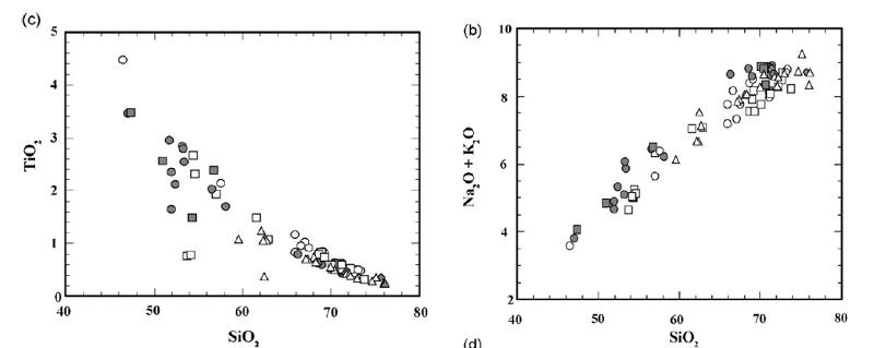
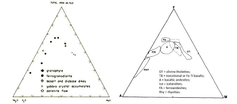
The broad characteristics of the evolution of a mafic magma toward a more felsic magma is understood from the classic Bowen's Reaction Series, addressed in other lessons, and from the short discussion of differentiation given above. The two graphs below are for more felsic magmas of the Mid Continent Rift from Vervoort et al ., "The magmatic evolution of the Midcontinent rift: New geochronologic and geochemical evidence from felsic magmatism", Precambrian Research 157 (2007) 235–268.
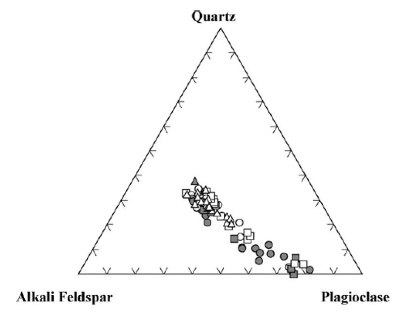
Consider the triangular diagram below (basically a piece from the Streckeisen classification diagram which was shown in the lesson on igneous textures and stories). This graph shows the trend of compositions among the more Felsic members of the Duluth Complex magmas, also from Vervoort et al ., "The magmatic evolution of the Midcontinent rift: New geochronologic and geochemical evidence from felsic magmatism", Precambrian Research 157 (2007) 235–268.
Tholeiitic vs Calc-Alkaline Magmatic Series
There are two broad types of non-alkaline magmatism, both exhibiting evolutionary progression from basaltic to rhyolitic composition. These two trends are the tholeiitic trend and the calc-alkaline trend. The tholeiitic trend is characterised by an iron enrichment which the calc-alkaline trend lacks (probably because higher oxygen activity in the calc-alkaline trend stabilizes magnetite on the liquidus earlier in the crystallization process and thus removes iron from the melt, preventing it from becoming concentrated). Tholeiitic trends are typical of divergent plate boundaries and many hot spots, whereas calc-alkaline trends are typical of subduction zone magmatism. The hand-drawn illustration below shows the iron-enrichment trend on an AFM diagram (A stands for alkalis like Na2O and K2O, F stands for FeO and Fe2O3, and M stands for MgO). Notice that both trends show a progression from mafic magmas (basaltic) to felsic magmas (rhyolitic). note: MORB = Mid-Ocean Ridge Basalt.
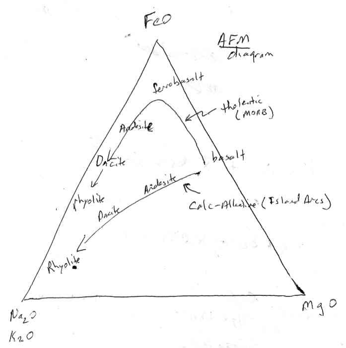
The AFM diagrams below come from "Geology of the Duluth Gabbro Complex near Duluth, Minnesota", by Richard B. Taylor, 1964, Minnesota Geological Survey Bulletin 44, University of Minnesota Press, and from "Geologic and Geochemical Evidence for the Nature and Development of the Middle Proterozoic (Keweenawan) MIdcontinent Rift of North America," by John C. Green, Tecronophysics, 94 (1983) 413-437.
Layers and Zones:
The Layered Intrusive Complex at Duluth can be divided into 7 zones based on the kind of rock. These zones are
- 1) The basal contact zone made of coarse-grained olivine gabbro and augite troctolite
- 2) The troctolite zone, made of cumulate olvine
- 3) The cyclic zone, made of repeated alternating layers of olivine rich (troctolitic) and gabbroic cumulates (see picture at top of page)
- 4) The gabbroic zone, with persistent gabbroic cumulates
- 5) The upper contact zone, with common quartz ferromonzodiorite
- 6 and 7) The Anorthosite series, with abundandant anorthosites crosscut by intrusions of melanogranophyre
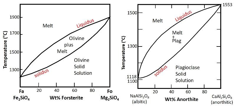
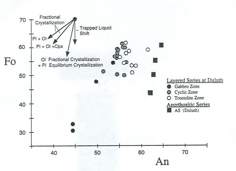
In addition to this mineralogical layering in the complex, there is also a change in the chemical composition of the minerals in the layers (called cryptic layering). Remember that some minerals exhibit solid solution between end member compositions, such as olivine having solid solution between Forsterite (Mg2SiO4) and Fayalite (Fe2SiO4), or plagioclase having solid solution between Anorthite (CaAl2Si2O8) and Albite (NaAlSi3O8). From the phase diagrams of these solid solution minerals (shown below), we can see that the compositions of the olivine will become enriched in Fe as temperature falls and crystalliization proceeds, and the compositions of plagioclase will become enriched in Na as temperature falls and crystallization proceeds.
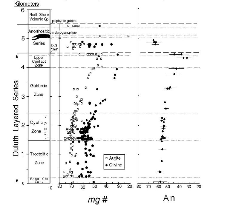
We can, then, talk about the magnesium number of the olivine, a measure of how much of the olivine is forsterite [Mg# = magnesium number = 100 x Mg/(Mg + Fe2+)]. We often talk about Anorthite content of plagioclase (0 to 100%) to indicate how much of the plagioclase is anorthite. Mg# and Anorthite content of minerals are reported for the different layering zones in the Duluth Complex in the chart below from Miller, J.D., 2009, "Field Trip 1: Duluth Complex at Duluth, in Field guide to the geology and mineralization of mafic layered intrusions of the Duluth and Beaver Bay complexes, northeastern Minnesota." Precambrian Research Center Guidebook, 09-01, p. 1-23. "Up" on this chart is toward higher levels within the magma chamber.
Fractionation Trends:
Consider the graph below showing anorthite composition (%An) and olivine composition (using % Fo rather than Mg#) for several different zones in the Duluth complex (unfortunately I have lost the source for this graph--it is not mine). Based on phase equilibria and partitioning, one can predict how the composition should change with progression of crystallization of different phases (each contributing a different D value) and with equilibrium versus fractional crystallization. These predicted trends are also shown on the graph.
Sedimentary Case Studies:
Introduction:
Sedimentary processes are complex, with sedimentary rock textures being influenced by weathering, transport, deposition, and lithification, by the different environments in which each of these occur, by the durations the sediments spend at each stage, by the composition of the source (provenance) of the material, and so on. However, we can identify a few 'first pass' relationships that are useful to hold onto and compare against in studying a rock.
One of these first-pass ideas involves the concept of maturity. As a sediment matures (during transport and ongoing weathering in the environment of deposition), grains become more rounded, sediments generally become better sorted, and unstable minerals, like the mafic minerals olivine and pyroxene, are weathered to clays. Feldspars and micas are more stable than the mafic minerals, but they too are quickly weathered away to clays and soluble matierals. Quartz and clay mineras are among the most stable and tend to remain after long weathering. Thus, a 'supermature' sediment might be one with mostly quartz that is well rounded and well sorted.
An illustration of maturity, as indicated by rounding and sorting of grains, is shown below, modified from Powers, 1953, A New Roundness Scale for Sedimentary Particles," Jrnl of Sedimentary Petrology, v. 23, No. 2, Pp. 117-119 (rounding, with other sources) and Folk 1951, Petrology of Sedimentary Rocks (sorting).
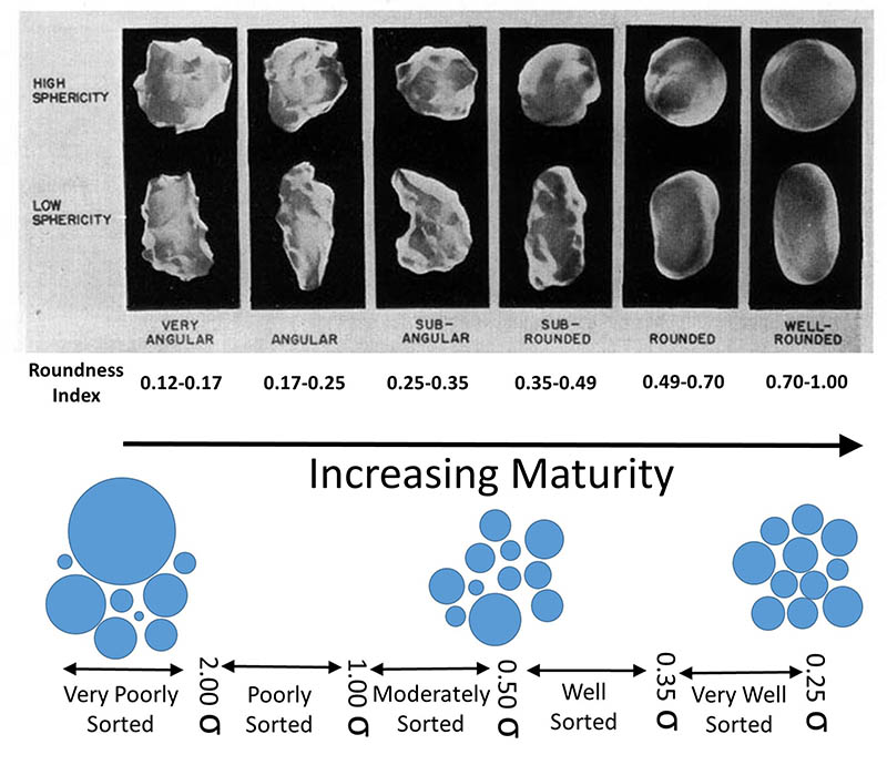
We can relate the rounding and sorting to various degrees of maturity for a sandstone as shown below (adapted from Folk 1951)
- Immature: Sediment contains over 5 percent terrigenous clay matrix; sand grains poorly sorted and angular.
- Submature: Sediment contains under 5 percent clay, but sand grains are still poorly sorted (at over 0.5) and are not well rounded.
- Mature: Sediment contains little or no clay, and sand grains are wel lsorted (at under 0.5), but still not rounded.
- Supermature: Sediment contains no clay, sand grains are well sorted and well rounded
Although maturity depends on the nature of the source sediment and distance of transport as well as the environment of deposition, if we consider other factors to be equal, then maturity of sediment gives us some insight into the environment of deposition. For example, we might expect a relationship such as the one below for selected depositional environments (adapted from Folk 1951 and other sources).
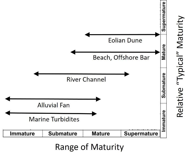
Eolian processes are particularly effective at rounding of grains and so the most well rounded sediments (over 0.7 roundness index, say) are often indicative of at least some wind abrasion.
In addition to size, sorting, and rounding of grains, details of the size distribution of particles in a sedimentary rock can provide clues about a rock's depositional environment. For example, consider the charts below showing different distributions of particle size [Phi = -log2 (particle size in mm), a common unit of measure].
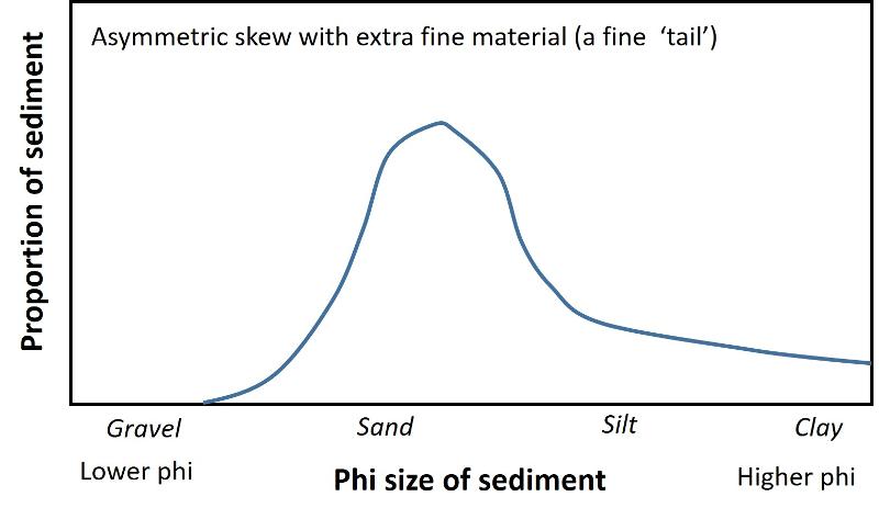
A non-symmetrical distribution of particles sizes, called 'skew,' is shown in the graph above. A skew with a fine tail is a characteristic of river deposits where waxing and waning currents are typical, with the smaller tail being deposited during episodes of waning current. This is called a positive skew. Dunes can also have a positive skew because coarser particles are not readily transported and deposited by wind, creating a 'cut off' at lower phi, although dune sands usually won't have a pronounced fine "tail".
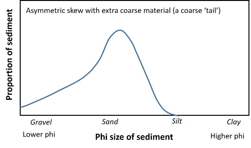
Another type of non-symmetrical distribution of particles sizes is shown in the graph above. A skew with a coarse tail is a characteristic of environments where the movement of water or air is inadequate to remove coarse particles which remain as a lag--creating the coarse tail--but successfully winnow away smaller particles creating a "chopped off" hi-phi limit. This can include beach and shoreface deposits. This is called a negative skew.
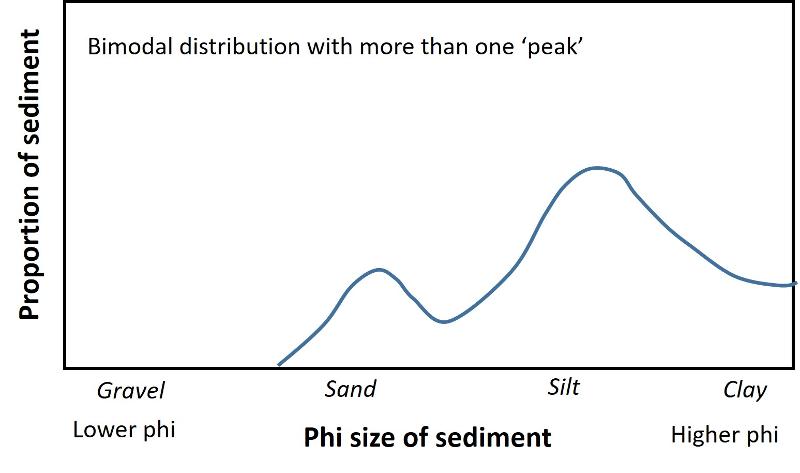
A bimodal (two-modes) distribution is shown in the graph above. A bimodal distribution can be indicative of the operation of more than one depositional process, such as both water and wind-born deposition in a lagoon, or introduction of periodic storm deposits in a normally low-energy environment (where the periodic influxes of coarser sediment gets mixed in to previous sediments e.g. through bioturbation).
In addition to these 'graphical' measures of sediment texture (which I will emphasize in this lesson), modern sedimentology emphasizes what might be called 'macro' textures in the rock, things like ripple marks and crossbedding, which play a critical role in helping to constrain the environment of deposition. Stratigraphic relationship between the rock and surrounding rocks is also important in interpretting sedimentary rocks. We will look at these important features less in this lesson than they deserve mainly because these features are generally 'bigger scale' than what you can see in a classroom hand sample, and also because addressing these features is more narrative in nature and more difficult to include in this type of interactive lesson, but I will give you a couple of examples so you can see how these other features are used and why they are often the most important parts of a sedimentology study.
A Hadrosaur Bone Bed
The exercises and illustrations in this section are based on or modified from Colson M. C., Colson R. O., and Nellermoe R. (2004) "Stratigraphy and Depositional Environments of the Upper Fox Hills and Lower Hell Creek Formations at the Concordia Hadrosaur Site in Northwest South Dakota," Rocky Mountain Geology v. 39, no. 2, 93-111.
This study attempted to constrain the environment of deposition of a suite of Hadrosaur bones in North Central South Dakota. The bones from this site were nearly mono-species--that is, dominated by hadrosaurs at the expense of other species--which is traditionally interpretted to mean that they might represent a catastrophic deposit, such as a deposit formed when a herd of hadrosaurs drowned while crossing a flooding river and were swept away and accumulated at a spot in the river where they get deposited.
However, there were a number of observations that seemed incomsistent with that interpretation in this case: including
- The bones are exceptionally disarticulated, with few or no whole specimens. Why would this be the case if they were buried rapidly by a flood deposit?
- The bones are preserved in a clay-rich layer. If this were a flood deposit, or accumulations at a point bar, such a fine-grained nature wouldn't seem to be expected.
- The sediments below the bone bed include glauconitic sandstones, ophiomorpha burrows, and other clear indications of a marine origin. If this were a river flood deposit, the proximity to a marine environment would seem to be an unlikely coincidence.
- Finally, the bones are found in an organic-rich clay deposit that can be traced region wide, something that seems unlikely for a river flood deposit or point bar.
The paper proposes to test an alternative model: The bones were deposited in a region-wide low energy coastal environment (swamp) with both a high organic production rate and a high sedimentation rate. The bones were probably not transported far from the environment in which the hadrosaurs died, and were not associated with a flood event.
The illustration below from Colson et al (2004) shows this model, with the location of the hadrosaur bone bed marked by a star at the edge of a body of standing water within a swamp at the edge of a sea. The beach ridges consist of coastal dunes, and the allluvial plains consist of distributary channels and rivers flowing into the swamp.
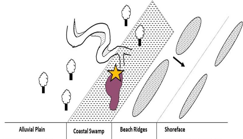
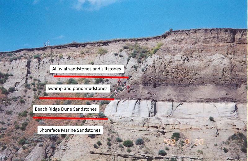
At the end of the Cretaceous, these environments were all prograding into the Cretaceous interior sea (marine regression), so that the dune sediments of the beach ridges lie above the shoreface sediments, the coastal swamp sediments with the bone bed lie above the dune sands, and the river sands of the alluvial plain lie above the coastal swamp deposits at the location of the bone bed, as shown in the outcrop picture below.
Questions that need to be answered to believe this model include:
Are the sandstones and other sediments overlying the bone bed (the alluvial plain deposits) different from the sands of the dunes and sands of the beach deposits in the way expected for the model to be correct?
Are the bone bed deposits themselves more consistent with deposition in standing water in a swamp than with deposition by a flood at an oxbow or point bar?
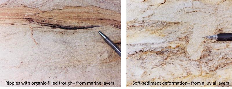
Examples of 'macro' texture features that were included in Colson et al (2004) are the following:
From the marine deposits: symmetrical ripple marks (characteristic of oscillating water--waves), with a trough filled with organic matter, is consistent with an intertidal zone.
From the alluvial sediments: Soft sediment deformation structures are characteristic of rapid burial of a still-soft sediment, such as might occur in deposition of channel fill and point bar migration in river deposits.
Supermature Sand Sheets: St Peter Sandstone
There are a number of supermature sand sheets from the Ordovician and before--prior to extensive plants on land which serve to stabilize sediments in modern environments but would have been absent in the ancient past. The St Peter Sandstone (Ordovician) and the sandstones of the Wisconsin Dells (Cambrian) are two of these. Understanding how these supermature sandstones developed helps us understand the nature of erosion in a world before land plants were abundant. There is a long history, going back to the early 1900s, of trying to understand if these are primarily eolian deposits or beach deposits, or some combination.
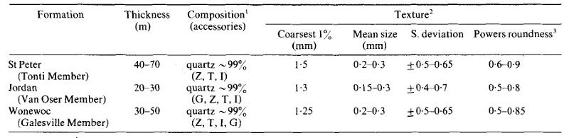
The table below comes from the article "Aeolian to marine transition in Cambro—Ordovician cratonic sheet sandstones of the northern Mississippi valley, U.S.A." by Dott et al (1986) Sedimentology, V 33, p 345-367. The rocks considered in this table are wholly or partially marine, but still seem to have experienced some eolian working.
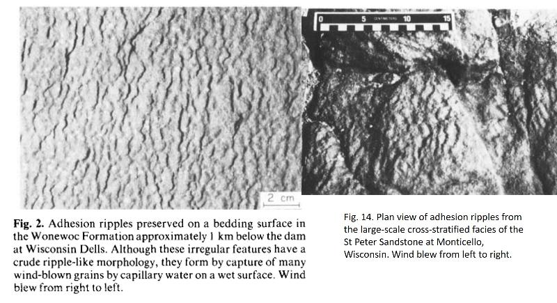
You can probably infer that the maturity information in the table above is inadequate to identify the depositional environments of these rocks that have been debated for over a century. In fact, the author's abstract, below, does not even mention this information, focussing instead on a complex variety of 'macro' textures--ripples and crossbedding-- in the rock. I have highlighted one particular texture, adhesion structures, characteristic of a type of eolian deposition also associated with beaches. After the abstract I provide the image for that particular feature from the authors' paper to give you a small glimpse of the author's use of structures and features in the rock to support their arguments.
Abstract from Dott et al 1986
Cratonic quartz sandstones have presented several intractable problems. Besides their extreme textural and compositional maturity and paucity of shale, their sheet-like geometry is particularly notable. If the sandstones were entirely marine, as long supposed, such geometry is difficult to explain in terms of modern shelf sediments, which are generally held to he either relict or only slightly reworked by the Holocene transgression (palimpsest). Re-study of two quartz sandstones in the northern Mississippi Valley region reveals evidence for significant non-marine deposition followed by varying degrees of marine reworking during transgressions.
Facies patterns are similar in the Cambrian Wonewoc and Ordovician St Peter sandstones, both of which overlie unconformities. In both, a large-scale cross-stratified,/ucies believed to represent aeolian ergs passes laterally into a p/unar-and-channel/rd,rueies inferred to represent sand plains composed of braided fluvial and aeolian sand sheet deposits. Criteria of aeolian. deposition in both facies include adhesion structures, large ripple index, fine climbing translatent lamination, grainfall and grainflow stratification. Criteria of braided fluvial deposition include shallow channels containing sequences of thinning-upward sets of trough cross-stratification, reactivation surfaces, low-index ripples, and polygonal cracks. Probable aeolian sand sheets contain flat bedding punctuated by small channels, adhesion structures, and coarses and ripples with large index. There is a conspicuous absence of trace and body fossils from these inferred non-marine deposits. In contrast is a burrowed and trough cross-stratifiedfucies characterized by mediumscale cross-bedding alternating with bioturbated intervals and rare brachiopod or trilobite-mould coquinas, which is interpreted as shallow marine. In both formations, this last facies replaces laterally and overlaps the other two, reflecting transgression and variable reworking. The main areas of non-marine deposits in both formations are capped by a thin, burrowed subfacies that represents the culmination of each transgression; that is, a stillstand during which sediment influx ceased and both physical winnowing and bioturbation were intense.
It is suggested that the sheet-like geometry of many cratonic quartz sandstones is due primarily to initial sand dispersal by aeolian and fluvial processes. That such processes must have been orders-of-magnitude more important on pre-Devonian, vegetation-free landscapes than they have been since, not only helps to explain the sheet-like character but also the exceptional maturity of the older cratonic sandstones.
Adhesion structures form when wind-blown sediment 'sticks' to a wet surface, forming ripple-like structures in the sediment. The images of adhesion ripples below are from Dott et al (1986)
Study of the morphology of grains can go beyond either simple sorting measures or even more sophisticated considerations of skew (and kurtosis). For example, consider the work of Mazzullo and Ehrlich (1983) "Grain-shape variation in the St. Peter Sandstone: a record of eolian and fluvial sedimentation of an early Paleozoic sheet sand." J. sedim. Petrol. 53, 105-1 19. They digitized the shape of many grains from the St. Peter Sandstone and fit the grain shape to a mathematical expression, with different 'harmonics' in the expression modeling different wavelengths of features in the grains (so, for examaple, the first 2-or 3 low harmonics might model the basic shape of the grain while higher harmonics would model perturbations, irregularities, and angularites of the grain). They then statistically evaluated the grains defined by the numerical modeling. They concluded that 90% of the variation seen in St. Peter Sandstone grains can be modeled by only 2 types of grains--two end members of their numerical shape modeling. They further associate these two end members with two types of transport mechanisms, concluding that the marine sands of the St. Peter Sandstone arrived at their marine depositional site via either transport by rivers or transport by wind, resulting in two different populations of grain types. In the exercise below, I present some of their results in graphical form, and your job is to figure out what their graphs mean, and associate their graphical data with their conclusions--which mathematical 'end member' cooresponds to real-world grain shapes and possible transport mechanisms?
A look at the Pierre Shale and the Cretaceous Interior Seaway
Although shales make up perhaps 65% of Earth's sedimentary rock cover, they are generally less well studied than sandstones and carbonates, largely because their small grain size makes examination of either the texture or mineralogy of grains difficult. We're going to consider a study that used X-ray diffraction and other methods to look at the proportions of Quartz and Feldspar in the Pierre Shale as a window into transport mechanisms and source of sediment to the Pierre Seaway in the Cretaceous.
The following exercises are derived from "Mineral Dispersal Patterns in the Pierre Shale", by Jones and Blatt, Jrnl of Sedimentary Petrology, 54, pg 17-28, 1984, and "Mineral Dispersal Patterns in the Pierre Shale a dissertation submitted to the graduate faculty in partial fulfillment of the requirements for the degree of doctor of philosophy" by Richard Lewis Jones, University of Oklahoma, Norman OK 1979.
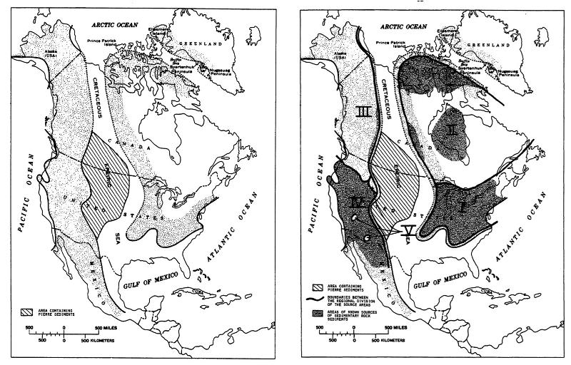
The map below shows the location of Pierre deposits and the inferred paleogeography at the time of the Pierre epeiric seaway, with possible provenance regions for sediments of the Pierre (areas I, II, III, IV, and V, with Area V = active volcanoes at the time of the seaway.) (from Jones, 1979)
Here's a picture from the camp at the Hadrosaur Dinosaur Dig in North Central South Dakota! Don't you want to be a geologist!?
last updated 12/3/2022. Text and pictures are the property of Russ Colson, except as noted.